
![]()
![]()
![]()
![]()
![]()
![]()
![]()
![]()
National Cycle Route (NCN)77 starts from the NCN7 at Ballinluig to Dundee, passing through Dunkeld, to Perth where it climbs over Kinnoull Hill, descending to cross the Carse of Cowrie, through Glencarse, St. Madoes, Errol, Kingoodie, Invergowrie,ending at the Dundee landfall of the Tay Road Bridge and the North Sea Cycle Route NCN 1
This part covers the 16 km / 10 miles of the 36 km / 22 mile from Perth to Errol
Back
This route is one of several possible routes between Perth and Dundee, all of them have one large drawback, the climb over the Braes of the Carse, which is the chain of hills running between Perth and Dundee.
This route, despite the climbing is infinitely preferable to actually cycling on the A90, take my word for it. It is not a pleasurable experience and should be avoided.
This route starts at the North Inch, Perth, which is one of two parkland areas given to the town in 1377 by King Robert III and has served numerous purposes since. King James IV (1488–1513) practiced his golf on the North Inch and horse racing was also held here in the past.
The Battle at the North Inch, 1396 was staged to settle a long running feud between the Cameron and Mackintosh Clans. Twelve to thirty picked warriors fought with swords, the party which should happen to be defeated would then be given indemnity for all past offenses and the victors, besides earning the lands in question, should be honoured with the "Royal favour."
As the crowds gathered, and the combatants appeared, one of the Mackintoshes, who had withdrawn himself from fear. The King then demanded that one of the Cameron's should be removed, as to equalise the number of combatants; to this proposal each and every Cameron man expressed a great unwillingness. As a result, one of the spectators, a local saddler presented himself before the King and offered his services, which were accepted, resulting in a fair and balanced contest. He survived, having joined the winning side!
Four of the Mackintoshes survived the battle, though they all were mortally wounded. Only one Cameron survived, saving himself by swimming the River Tay.
At the traffic lights cross the Tay (have a look at the by-law notice on the former fruit and vegetable shop to the right — especially important if you are the driver of a locomotive). Straight on at the next set of lights, the hill ahead is steep, narrow and makes for unpleasant for cycling.
Approaching Murray Royal Hospital, follow the road around to the right and continue climbing to the top and the Jubilee Car Park. Farther on, good views of the Tay and Friarton Bridge can be had from here
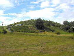
At the beginning of the descent and just before where the Coronation Walk joins the road, have a look on the right just up the farm road for a well camouflaged pill box.
 |
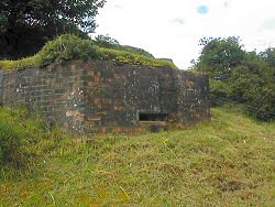 |
| Spot the pillbox | The pillbox |
 |
Defence of Great Britain Project |
| The commanding view from the pillbox |
The Coronation Road was the route that the Kings and Queens of Scotland took to be crowned at nearby Scone Abbey upon the Stone of Destiny.
After a short climb the road seriously descends, 20% or 1:5 gradient into Balthayock
At the T-junction turn left signposted for Glencarse, entering the village, turn right at the T-junction and follow the road running parallel with the A90.
Outside the village hall on the left hand side is a statue of what looks to be William Shakespeare, minus one hand.
Follow the road over the A90 heading towards Errol on the B958.
An interesting diversion, roughly 1 km or 0.8 mile after crossing the A90 is the Old Cottown Schoolhouse. Look for a left hand bend with a bus shelter to the right. If you turn right here and follow the track for two hundred meters, you will find on the School house on the left.
This a unique survivor of a traditional clay built, reed thatched cottage dating from 1745. The Schoolhouse was bought by the National Trust for Scotland and has been conserved using traditional techniques of earth building and reed thatch. The School house is not generally open to the public. Return to the B958 and turn right.
Entering Errol turn right at the T-junction and continue through the town.