
![]()
![]()
![]()
![]()
![]()
![]()
![]()
![]()
This woodland walk was created in 1996 when the Portmoak Community Council, The Woodland Trust, Scottish Natural Heritage, Gannochy Trust and Perth & Kinross Council, with Heritage Lottery Fund and grant-aided by Forestry Authority entered into Partnership with Tetley to establish a three mile circular walk around Kinnesswood and Scotlandwell.
This circular walk is a great way to savour the unique
characteristics of the villages of Scotlandwell and
Kinnesswood.
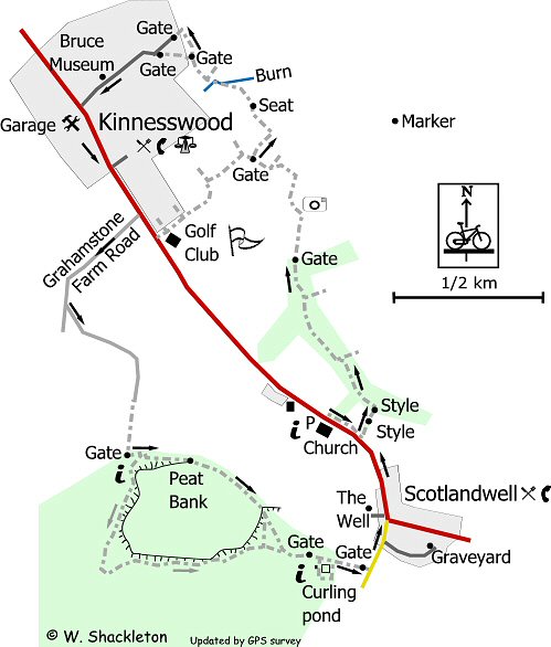
The walk starts from the Portmoak Parish Church traveling along the foot of Bishop Hill to Kinnesswood and returning to Scotlandwell through the Portmoak Moss community woodland.
Please note that it is essential that walkers should avoid using this church car park on Sunday mornings.
From the car park, cross the A911 and continue to the right along the footpath for a short distance to the steps at the roadside. Follow the path to the left for a short distance to a style, cross the field to another style at the tree line. Turn left and follow the path through the mature woodland, this path can be muddy in places so wear appropriate footwear. A grass track joins this path from the right, this is an old carters track from the quarries farther up on Bishop Hill.
The path emerges out of the wood at a gate and continues between the golf course and the bracken covered slopes of Bishop Hill. An orange marker can be seen high on the hillside to the right, this is to do with the Scottish Gliding Centre at nearby Portmoak airfield. Portmoak is a renowned centre for gliding and one of the best places for slope soaring in Britain. This path is a good vantage point for Loch Leven and the rest of Kinross-shire.
Near Kinnesswood there is a seat dedicated to the memory of Brian Glover the actor, who was the voice of the “gaffer” in the Tetley Tea commercials. The path reaches its highest point shortly after the memorial, a burn (small stream) crosses the path, before the path comes to a fork. Either way is OK, though I prefer continuing straight on to go through the northernmost “kissing” gate.
After the gate, follow the road downhill through the oldest parts of Kinnesswood a village. There are a number of “green” roads amongst the houses which are a unique feature of this village. About half way down the hill on the right is the Michel Bruce Museum. This cottage was where the “gentle poet” lived. The key for the museum can be obtained from Buchan’s Garage at the foot of the road. The large building opposite the museum was an early factory for the weaving industry, which died out in the village shortly after the industrial revolution began.
Turn left at the foot of the road and continue along the footpath out of the village. On the outskirts of the village, shortly after the 30 mph signs there is a farm road to the right for Grahamstone Farm. Follow this road down hill for a short distance before taking another more overgrown farm road to the left. The main crop at Grahamstone is turf so please keep off the grass! The farm road turns to the right ending shortly afterwards. A grassy path continues far a short distance before entering Portmoak Moss Community Woodland. The area around the entrance gate is very muddy. An information board can be found just after the gate.
The Tetley Trail follows the tree line, taking the shorter route out of the forest, if you have the time it is well worth taking the slightly longer route through the wood. Either way you will come to the peat bank, this was the “working face” of the local peat cutting industry and gives an idea of just how thick the peat under your feet really is.
Both paths come together before a gate at the edge of the forest. There is a path to the right which will lead to the old club house and curling rink. The Club house is no derelict and the pond is overgrown, both now superceded by the indoor rinks. A rough path goes around the rink and joins the road, otherwise continue along the road to another fence alongside the road.
There is no footpath from here to the village. The best idea is to cross the road and continue to the A911 junction cross over, pass the Inn and up the hill to the church and starting point.
Scotlandwell is another village with connections dating back to Roman times, it was a monastic centre until the reformation. A connection with the church can be found by taking the first right into St. Serfs Close and following the road to it end. On the left is a railed off tomb stone and a memorial plaque marking the place of the Cludee Church. The plaque also commemorates the burial place of the family of Ebineezer Erskine, who was a leading element of the Secessionist movement, 1733 that established the independence of the church over the state. This is still the case in Scotland and amidst other things gives the parishioners the right to choose their own ministers, unlike the Church of England.
Opposite the junction for the A911, signposted for The Well is a roughly paved road leading to the Well of Scotlandwell. The waters can be seen bubbling up through the sand. The waters are attributed with curing the leprosy that afflicted King Robert the Bruce. The small building opposite the well was the old communal wash-house dating back to the days before the invention of the washings machine. The grass park was once used as a drying green, used for drying cloth after it was bleached. It is worth noting that in the days before the invention of Sodium Hypochlorate (bleach) urine was the bleaching agent most commonly used.