
![]()
![]()
![]()
![]()
![]()
![]()
![]()
![]()
Tucked up in the northern reaches of Dunning Glen lies Greenhill and Knowehead Forests.
Four colour coded way marked walking trails have been laid out in Greenhill Forest; Red, Blue, Orange and yellow. In contrast there is nothing at all in Knowehead Forest, except the surprise of finding a working farm amongst the trees.
To be honest there is nothing much of interest in either forest except somewhere peaceful to go walking.
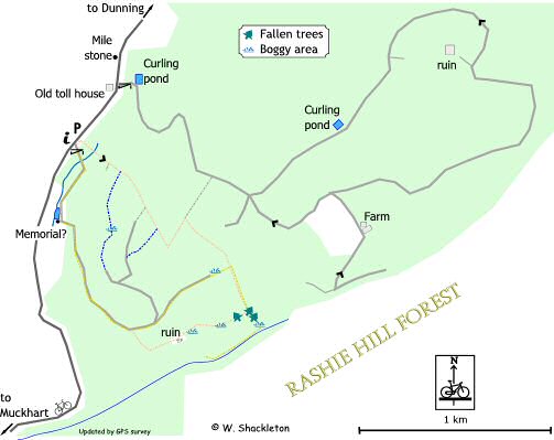
Greenhill Forest.
Of the four way marked walks the blue route is the best and the yellow the worst, in fact it was so bad that I did not managed to complete this circular route.
All the routes start from the same point, that is the car park off the Dunning Glen road, go around the gate and down the hill to a small loch, which may have been a curling pond. It is certainly man made, the banking on the southern side has been built up and the water level is controlled by a weir. There may also have been a memorial plaque at the base of the embankment, though to what I do not know.
Orange Route
The orange route leaves the track first, by going off to the right along a fire break. At the end of the fire break there is a good vantage point down into Tonguey Faulds. The orange route continues for a short distance before coming to the remains of a farm, a sign that before the advent of commercial forestry, many people lived and worked in this area. There are three derelict farms to the north of the Faulds and another three to the immediate south.
After the farm the path becomes boggy before finally becoming blocked by fallen trees. The path then comes to a T-junction; the yellow route goes off to the right heading down hill into another tangle of fallen trees, while the orange route goes up the steep slope to the left, following the fence line northwards back to the car park at the start.
Remaining routes
The remaining routes continue along the forest track for a short distance before splitting at a Y-junction; the Yellow route continues straight onwards while the red and blue routes go to the left and up the steep hill.
Yellow Route
Shortly after the junction, the forest track is very badly surfaced, with large, loose stones as it heads down hill. At the end of the track the yellow route continues for a short distance as a boggy path before meeting up with the returning orange route. The yellow route goes to the right heading down hill into another patch of fallen trees, to the junction with the orange route then into the tangle of trees mentioned earlier. The path heads towards the burn then turns upstream. From now on the going gets worse at one point you will have to thread your way through the trees before gaining a clear way.
The path then comes to a clearing as the burn sweeps around in a wide arc, then after a final marker post (pointing into the trees), the path disappears. I gave up shortly afterwards, seeing no clear way ahead I was not going to spend the rest of the day crashing around in the trees. According to the map the yellow route follows the burn for a while before turning right to head uphill towards the Muckhart - Dunning road, to follow the fence-line back to the starting point. This route is very poorly way marked. All in all this route is not worth the effort.
Red Route
From the Y-junction, the red and blue routes head up the steep hill to another junction; the blue route continues straight on while the red route goes off to the right up another hill before levelling off. The red route continues for a short distance before the track comes to a dead end. The route continues on along a path for a short distance before it meets the orange route, turn left to head northwards back to the starting point.
Blue Route
This is the best of all the routes, from the parting junction with the red route, the blue route continues along a short length of track before it too comes to a dead end. The path goes off to the left heading slightly downhill before heading into the dense trees, along a wonderfully smooth path paved with pine needles. The path then emerges into a clearing with one or two boggy bits to spoil your enjoyment, and continues for a short distance along a fire break before heading into the trees.
The blue route finally emerges out to join the orange and red routes. The blue route turns right heading uphill along the fence line to another clump of fallen trees. The fence-line turns sharply to the left before the route turns sharply to the right. It is possible to follow the fence line straight on into Knowehead Forest.
The blue route continues for a short distance until it meets the red route coming from the right. Turn right, following the path, then forest road until you meet the blue route marker post on your left at the crest of the hill. Turn left to follow the path, along the fire-break until it meets the orange and yellow routes, turn left and follow your tracks back to the starting point.
Return leg
Shortly after all four routes join together the way marked trail goes down a steep slope carpeted with pine needles, following the fence line. Take care here as the going can be very slippy. The path at the bottom crosses a small bridge, you may turn left and follow the small burn down stream to the forest road and turn right heading uphill back to the starting point. The path after the bridge goes up a small embankment to meet up with the Dunning road and the car park at the starting point.
Knowehead Forest
There is not a lot to say about this one. The main road into the forest is also the main access for Knowehead Farm so it is well used and has a smooth surface dressing. At first the track climbs gently passing a small curling pond as it goes uphill then becomes steeper towards the top. One thing to note, if you are using the OS 1:25,000 scale Explorer map (369) watch out for the deliberate mistake, the forest road does not split, the one and only track passes the curling pond and does not go straight uphill bypassing the pond, this is in fact a fire break and not a road.
The road comes to a junction, turning left will take you around in a wide loop, past another curling pond and the derelict ruins of Broadheadfold Farm, to come close to Knowehead Farm before heading uphill back to the junction.
Knowhead Farm is a working farm, so respect their privacy
as you pass.
The other glaring omission on the Explorer map is the track south to Wester
Bankhead Farm, it simply does not exist anymore.