![]()
![]()
![]()
![]()
![]()
![]()
![]()
![]()
Boundary Stone
In times past the War Department marked the land boundaries of military establishments by small rectangular stones, usually inscribed with a number and the initials or markings of the parent Ministry.
I have seen similar stones at the WW 1 airfield at Montrose and at Leuchars which also dates from the same period. These stones are marked with AM for Air Ministry, while this stone is marked with an anchor, denoting the Admiralty, in connection with the then Royal Naval Dockyard at Rosyth.(I have also seen "modern" concrete Admiralty stones in Cromarty, c. WW 1)
The unusual feature about this stone is the directions of the land boundaries are indicated by arrows.
The stone was saved, when the wall in which it sat was demolished to make way for the Park and Ride facility at Ferry Toll. It sat somewhere along the fence on the opposite side of the road near the double gate. It is presently sited beside the roundabout outside the Park and Ride.
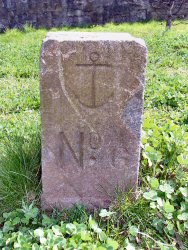 The No.6 boundary
stone, with an anchor
The No.6 boundary
stone, with an anchor
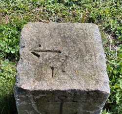 The
top of the stone with the indicators.
The
top of the stone with the indicators.