
![]()
![]()
![]()
![]()
![]()
![]()
![]()
![]()
Following an ancient roads which carried traffic and drovers from the North, to the south by way of the Minigaig and Comyns’ Roads to Blair Atholl and Perth.
The part of the 24 km or 15 miles route could be combined with the B9152 (old A9) to form a day route from Aviemore to Kingussie.
Back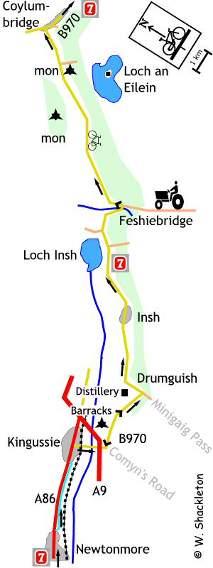
Continue through Newtonmore passing the Highland Wildlife Park on your right. Just after the park, signs direct you to the new cycle path on the right, which runs parallel with the A86.
Follow the well surfaced path, alongside the A86 to Kinguissie. Shortly before the town, the path crosses over a couple of semi-stagnant burns which are ideal midge breeding grounds, to turn sharply up a slope to come to the A86 road, a hill start here on a fully loaded bike is not a pleasurable experience.
Turn right to join the road into Kingussie. Turn right at the Osprey Hotel and follow the road past the station and level crossing, heading towards the A9 passing the Kinguissie Shinty pitch to go under the A9 and up the short hill to the Ruthven Barracks.
The barracks were built in 1719 following the first Jacobite rebellion of 1715. The barracks were captured and burned by the Jacoblites during the second rebellion and were never rebuilt, the power of the rebellious clans being crushed forever. The ruins can be explored without charge.
Follow the road around to the left past the barracks and down a steep hill. A short while later you will cross the Tromie at the end of the ancient Minigaig road between Kingussie and Blair Atholl. The other ancient route, Coymns Road started from the bend near Ruthven Barracks also heading for Blair Atholl. Of these two, the Minigaig was the main route to the south, falling out of favour when a party of soldiers froze to death on the route during a winter storm and remained in use until well after Wades Military Road was built. Communications with the highlands were not fully developed until the opening of the railway in the mid 1800's.
The second distillery, the Speyside Distillery is to the left just after Tromie Bridge, unfortunately it is not open to the public.
The road continues by woods and fields, passing through the hamlet of Insh to arrive at Feshiebridge. The views of the water below are dampened by the prospect of a short steep climb on the far side of the bridge.
If you have the time it is worth venturing off the B970 to see the picturesque Loch an Eilein, surrounded by trees the loch has a ruined castled on an island.
At the junction of the B970 and the Loch an Eilen road there is a monument to James Martineau, 1805 to 1900. Who according to the inscription on the memorial was a Unitarian minister and educator scholar and philosopher who loved this area and on retirement made his home here.
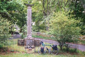 Martineau memorial
On the left hand side of the road is the distinctive hilltop monument to the 5th and last Duke of Gordon, 1770 - 1836. Also on this hill is a monument erected to the memory of the soldiers of the Gordon Highlanders who fell at the battle of Waterloo, June 1815
Apporaching Inverdrurie / Coylumbridge you will get your first views of the mighty Cairngorm and Braeraich Mountains In between them is the narrow Lairig Ghru Pass, which was the main route to Braemar. It is a testament to the remoteness of this area that a road was never built following this route.
At the end of the road you will come to a T-junction, turn right. (To the left is Aviemore) continuing along the advisory cycle lane. The route is not too well way marked following this junction.