
![]()
![]()
![]()
![]()
![]()
![]()
![]()
![]()
This is the final part of the run to Inverness, and it is not without controversy. The final 27 km 17 m of NCN 7 leaves Culloden to go through a forest an impossible cycle gate, the route as it enters Inverness has to negotiate a large and busy roundabout, it also goes through a shopping precinct and there is confusion as to where the route ends - the Tourist information centre or the Leisure pool?
Back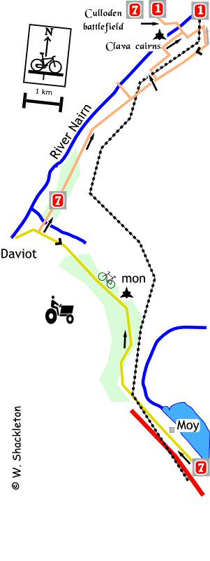
After the noise and the bustle of the A9, the road through Moy is a joy and should be savoured, you are on the last stretch of the route. To the north of Moy the railway line crosses a burn by a magnificent (and unusual) timber bridge marvel at the size of the beams and that in this day of pre stressed steel and concrete there is still in use for timber.
Following a railway bridge the road sweeps around, there are traces of the old military road on the bend and after that in the “middle of nowhere”, is an ammonia and Nitrous oxide monitoring station established by the, Centre for Hydrology & Ecology Banchory. www.ceh.ac.uk
On the right hand side practically opposite a small loch is a stone pillar, commemorating the reconstruction of Inverness Perth Road the first turf was cut by Mrs Macintosh, wife of Col. Macintosh of Macintosh CBE Lord Lt. & Convener of Inverness, 6th May 1925, (I wonder how many more roads the Macintoshes opened?). The road was originally constructed by General Wade who began the work in 1728.
 Roadside cairn
Following the stone the road descends, ahead is a good view of Ben Wyvis to the north of the Black Isle, the descent increases to a 10% gradient shortly afterwards. Ahead is the old Daviot Church beside the A9, this is the last time you will see the A9 until crossing over it outside Inverness, the route turns to the right near the bottom of the descent, this turning is poorly way marked.
Turn onto a single track road with passing places, continue along this quiet road for a while until turning left signposted for Clava C222 and descend steeply, in the distance you can see the next landmark the Nairn Railway Viaduct. Be wary descending as there are lots of loose stones on this road.
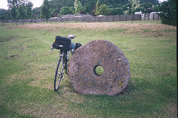
Following a sharp bend the road passes through part of a stone circle, this is just a small part of the Clava cairns, and it is well worth taking the time to have a look around the prehistoric burial Cairns of Balnuaran of Clava, which are thought to have been built by farmers and herdsmen of the 3 to 4th millennia . To visit, continue through the circle and turn left into the car park.
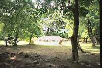 One of the Clava cairns
Return to the road, turn left heading towards the viaduct and a T-junction, to join with the North Sea Cycle Route, NCN1, which has come up along the east coast, Aberdeen and Elgin. At the T-junction, turn left, from here on until the River Ness you follow a joint NCN 1 & 7 route.
Clava to Inverness
There then follows a long and gradual climb through
a wood, at the top is a cross roads, go straight on. Cross straight over
at the next cross-roads, not too far away to the left is Culloden battlefield
the site of the last battle fought on British soil, between the Government
forces and the followers of Charles Edward Stuart, Bonnie Prince Charlie.
The outcome of this battle changes Scotland forever, continue on, the
National Trust
charge for the privilege of visiting the battlefield and besides on a
dreich day it's a spooky place!
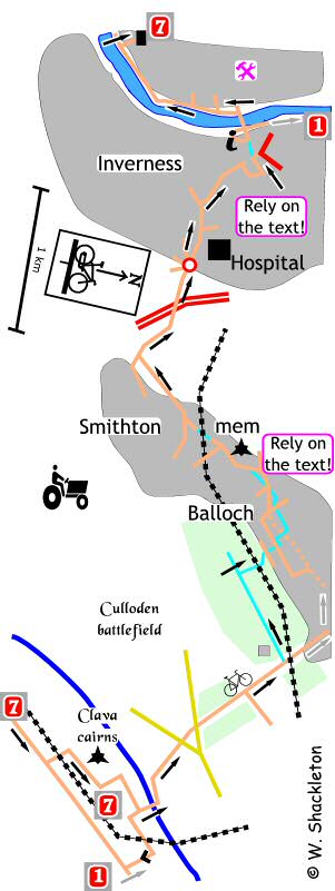
The road descends as you head towards Balloch, turn just as you enter the village, towards the Inverness College Department of Forestry. Benefit from my experience, avoid this next section if you have a loaded bike. The forest road is rough and the last of three gate is impossible to get a bike through without taking all your panniers off.
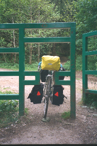 The impassible gate, Balloch
For the record the route through the forest has three gates, the first is no problem except for the rusty bolt protruding from the gatepost. Come up to a cross-roads go straight on to the second gate is missing, though the pedestrian gate is impassable for cyclists (the first time I came this way I had to go into the trees to get around this gate). The next junction is not way marked except with a Smithton & Culloden footpath sign, turn right and descend on the rough path. Go under a railway bridge and follow the path around to the left, descending down to a set of green access gates which are the most useless things that ever been put on this earth for getting a bike through.
After the gate follow the path down through the trees to a road, cross over and continue on the shared use footpath, at the next road cross over, turn left and continue on the shared use footpath. At the octagonal doocot turn left and continue to another road, go straight over and turn right, then turn left onto a country path going through a set of double gates onto a shared use footpath, at the unmarked junction cross straight over come up to a builders yard and follow the road around to the left. At the cross-roads amongst some houses and turn right.
At the next junction turn left onto Smithton Park, on the right hand side is a grassy park, just beyond the wooden seat is a plinth bearing the inscription Shackleton Park, this park named in memory of the Shackleton bomber, of 120, Coastal Command Squadron, which crash landed near this site on 10th January 1964 it commemorates the heroism and skill that saved both the community and the crew from disaster.
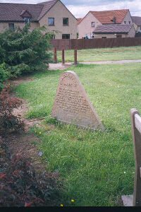 Shackleton Park memorial
As the road bends around to the left go straight on, this is poorly way marked onto the unnamed road, no signs except a “No Entry except for bicycles” signpost. Go under the railway bridge, under the bridge is a barrier, go around the gate and continue along the road.
At the top of the hill, follow the road around to the right, could do with a repeater signpost on this road. At the T-junction with a busy road and turn right, at the traffic lights go straight on crossing over the A9.
You now come to the Raigmore roundabout, take the 4th exit on this busy roundabout signposted Raigmore Hospital. There follows a set of traffic lights with an advanced stop area, go straight on. At the roundabout go straight on. Cycle lanes sprout at the road side, the first since Aviemore, turn right at the lights, (with an advanced stop area.)
Go straight on at the next set of lights follow the road around to the right between a church and Inverness College, Midmills building. At the bottom of the hill turn left into the pedestrian precinct, no way marking here. There is not sign of any shared use footpath through the precinct, so strictly speaking you have to dismount and walk through the precinct – yeah right!
At the end of the precinct, go straight on… it may be easier to use the set of pelican lights to the left beside the MacDonald’s to cross the road.
According to the Sustrans web site, the tourist information centre to you left is the end of the NCN 7. However the stickers continue past the TIC and over the Ness Bridge to turn left and head upstream, NCN 1 goes to the right just before the bridge and goes down stream
Turn left after crossing the Ness Bridge, and follow the river upstream along Ness Walk, at the large church, go left continuing upriver, no way marking here other than a green & black arrow.
At the Eden Court Theatre turn left into Ness Road, no way marking, continue down passing the playing fields, turn right into Bucht Drive, and left at the end of the road, watch out for the dangerously aligned drain gratings at this junction. The red arrow is the last way marker for NCN7; the route ends at the pool, though there are traces of something at the Rugby Ground at the end of the road.
 The end of the NCN 7?