
![]()
![]()
![]()
![]()
![]()
![]()
![]()
![]()
outdoor shops of Inverdrurie and the large Coylumbridge Hotel behind and heads into the peaceful countryside, shattered only by the whistling of a steam train rattling off the hillsides. The railway and the
river meet at the Boat of Garten. Where you will come to the northern terminus of the Strathspey Steam Railway, (run by “nutters” for “nutters”) and then after a gentle climb into Carrbridge. Back
The road ahead has cycle lanes, which are a token gesture, as they disappear when the road narrows just short of the Coylumbridge Hotel. There are no repeater signs on this stretch of road, could do with some as there was a degree of uncertainty about this part of the route.
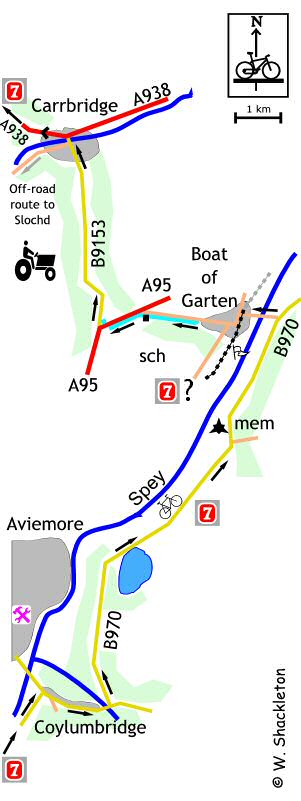
As you enter Coylumbridge you cross the bridge and turn left remaining on the B970 for Boat of Garten. For aficionados of real trivia there is a Victorian Post box to the right just after this junction. I stopped for a brew-up not long after this junction and in typical fashion it started to rain and just as typical the rainl stopped when I finished! Still the views of Loch Pityoulish through the Scots Pines made up for the dismal weather.
 Loch Pityoulish after the rain
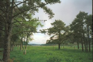
A further on after rounding a bend you will come across bizarre sight – an animal “zebra” crossing with cat-flaps in the road-side fences and a wavering dotted line in between… otters?
 Otter crossing
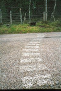
Just beyond that, is a cairn, in memory of John Roy Stuart 1700-1752, who was born and raised near this spot. Apart from being a celebrated Gaelic poet he was also a Jacobite commander during the `45 rebellion. He raised the Edinburgh Regiment which also included men from Strathspey. He won great acclaim for his bravery at Prestonpans, Falkirk and managed to survive the Battle of Culloden.
 John Roy Stuart memorial
Farther down the road, after passing through the Street of Kincardine you turn left for Boat of Garten. There is a plinth on the far side of the bridge over the Spey, erected by the Inverness County Council commemorating the old wooden bridge, which served the area 1899 until it was replaced in 1974. The village takes its name from the ferry which used to cross the river at this point.
From the Spey, climb the gentle hill, go under the railway bridge and follow the road around to the left then around to the right in front of the hotel. There is a confusing route sign just afterwards, a way marker looks like there is another route from Aviemore.
The Steam railway – I love these places, though here, I was accosted by three “jobsworths” in quick succession and rebuked by the Station Master for riding a bicycle on an empty platform. Hard thing to take, coming from a man with a sunflower in his hat. That said and done, the station was full of steam things, which is why I stopped there in the first place. I watched a train come into the station managing to ran out of film at the critical moment then watched the passengers alight and then quickly embark on a coach for their next port of call on their “See all of Scotland, in three days” tour.
There is a new shared use footpath on the outskirts of the village starting at a lay-by, a wonderfully smooth surfaced, though undulating track runs parallel to the road. I was beginning to form the opinion that all the effort to build this footpath was wasted, feeling that I would have made better progress on the reasonably quiet road when I came across the local primary school and what I saw there warmed my heart, the bike shed was absolutely crammed full of children’s bikes. So all the effort to make the track was not wasted after all.
Past the school and follow the cycle path around to the left alongside the A95. A short distance later you cross the A95, continuing on the footpath on the far side. At the junction, turn left on the B9153, which was the A9, to Carrbridge.
The road into Carrbridge climbs a little though nothing much. The Landmark Centre is amongst the trees to the left as you enter Carbridge. At the roadside there is a traction engine and a memorial to Karl Fuchs, 1924 – 1990, who founded of the Austrian Ski School in Carbridge (you pass the school on the A95).
There are confusing way markings in Carrbridge, just before the bridge there is a sign tucked amongst a nest of other road signs, directing you to the off-road route to the left, while across the river there is a sign directing you to that left. As I did not have an up to date route map, I decided to ignore the off road route and take my chances with the route over the bridge. It turns out that the off-road route is newly completed and I made the right decision after all.
Beside the new river bridge is the remains of the 18th century pack horse bridge. Its parapets and sidewalls were badly damaged in the 18th century and again in the floods of 1829, giving the appearance it has today. There is an interesting story board beside be bridge and a good photographic viewpoint.
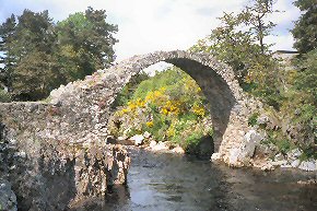 Old river crossing, Carrbridge