
![]()
![]()
![]()
![]()
![]()
![]()
![]()
![]()
One of the interesting “discoveries” I made
came from the old A9 Findhorn Bridge, just outside Tomatin. This bridge
was designed than none other than the same man who
designed the Wembly Football Stadium, which explains why the grass is
all torn up and the goal posts are missing!
Carrbridge, cross the bridge and turn left, follow the road through the forest to its junction with the A9, turn right just before the junction, going through what appears to be a set of gates onto the old A9 once again. It is easy to be misled thinking that this is a closed road but it is actually open for the traffic going to Slochd.
The road passes under the impressive A9 viaduct, the thundering traffic overhead contrasts with the peace and tranquility of the road below. After the viaduct, you round a bend and enter Slochd, which is no more than a handful of houses with an impressive name. Here I found a variation on a theme here instead of the usual “Slow Children” sign (never seen a slow one yet!) this one was “Slow Elderly Walking Person.” Accruate and concise!
Shortly after passing under the A9 viaduct there is some kind of cycle shop to the left, looks like a hire place though it is good to know in case of emergency.
Before the junction with the A9, turn left to come up to a gate, go through the gate and continue along this section of traffic free road, which sweeps around to cross a bridge then climbs gently heading towards the new A9 and Slochd summit. The road gets progressively narrower as it nears the top eventually narrowing down to a footpath as it is hemmed in between the road and the rock face. The road, railway and path all converge at the top of the narrow pass. The cycle path passes through a gate to continue under a rock face with evidence of a recent fall of small stones. Go through a second gate, onto old A9. The radio mast marks top of the pass. Slochd summit 405 m /1328 ft. Over on the hill side to the right is a small standing stone, this marker stone is at the junction of two routes contemporary with the military road. In the lay by on the right hand side is the original A9 summit marker.
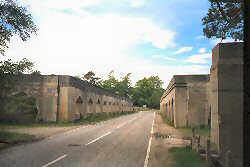
The footpath ends at the Raigbeg / A9 road junction, turn left onto a long gradual descent, after that is a steeper 8% descent, to the River Findhorn and brutally stark concrete bridge, being built when reinforced concrete construction was in its experimental phase. The formal mid span inscription echoes the ties of the past and the optimism inter-war period, contrasting with the fact that the bridge was opened at the time of the Genral Strike “This bridge was built in 1926 to replace the bridge built by Thomas Telford 1833. Colonel the Macintosh of Macintosh CBE Lord Lieutenant the Conveniener of the Inverness County Council (and) Lt. Col the right honourable Wilfred Ashley MP Minister of Transport opened the bridge.
 Findhorn
Bridge
Findhorn
Bridge
On the north end of the bridge is the name (Sir) E Owen Williams… the bridge designer, whose most notably designed the Wembly Football Stadium, which opened in 1924.
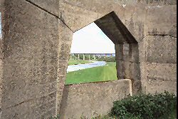
Over to the right can be seen the viaduct of the bridge built for The Highland Railway, which was built in 1897, as part of their direct line from Aviemore to Inverness. It was designed by Murdoch Paterson. It is a nine span structure with double-Warren steel trusses on masonry piers. This is the only large bridge of its type on the Highland system, though they were much used by the Caledonian and North British railways.
 The
railway viaduct seen through a bridge window
The
railway viaduct seen through a bridge window
About a mile or so outside Tomatin village is Tomatin Distillery which is open to the public. Shortly after that is a Little Chef and Filling station and the Tomatin road meets the A9. The turning at this junction is poorly way marked could do with a sign on right hand side pointing to the left. The only indication that you do go left is stickers on a post, way back in the pecking order of 11 signs at this corner.
Turn left onto old A9, the road eventually becomes a no through rough road becoming hemmed in between the forest and the A9. The road eventually ends, continuing on footpath to the right going down to run parallel with the A9.
Go through two gate / cattle grids straddling a side
road and continue on the footpath. The path comes to a lay by just short
of the Ruthven junction. Go left along the lay by at the end of the lay
by. There is a not too well way marked footpath leading to a bridge. You
then have to take your life in your hands and cross the A9, going along
the other side of the road. The close proximity of the traffic comes as
a rude shock to the senses.
Fortunately, the footpath soon ends at the A9 / B9154 Moy junction, turn
right heading for Moy.
Over on the A9, a road sign declares – Inverness to be 14 miles away, while the Sustrans Inverness sign is 19 miles. Stick to the Sustrans route its quieter by far!