
![]()
![]()
![]()
![]()
![]()
![]()
![]()
![]()
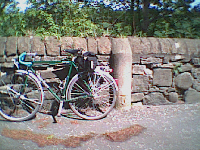
The start of this route is quiet and tranquil, finishing in the city where you will need eyes like a hawk and reactions like a nervous wildebeest.
Following the route into the city is not easy, looking out for the signs and the red "1" stickers AND keeping an eye on the traffic is not easy, especially in George Street. Take care!
Back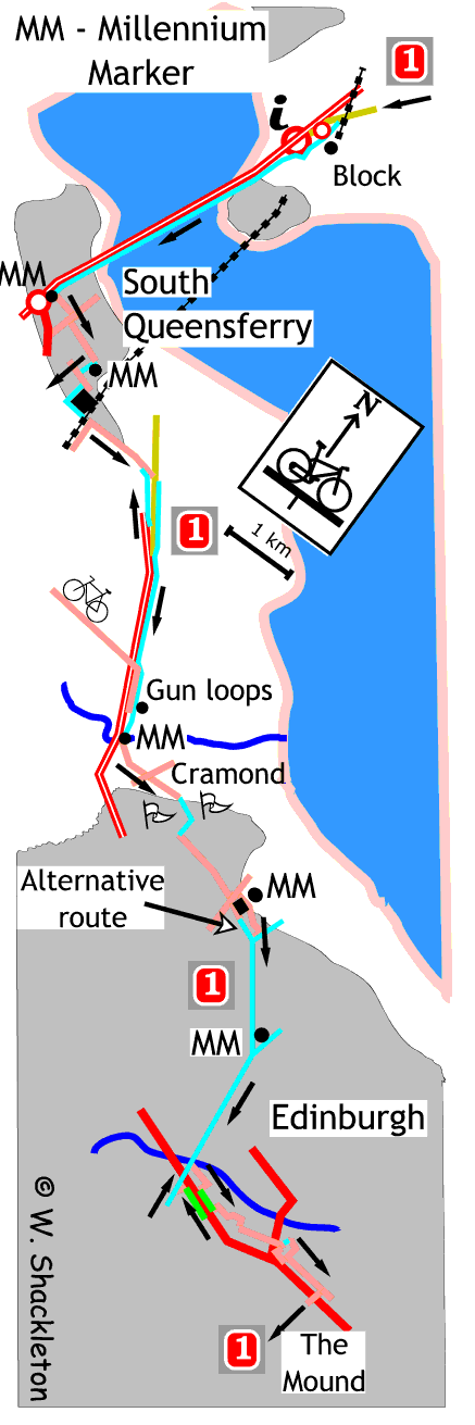
Come off the south bound bridge service road and continue in front of the control building then go up the slip road to the A8000. Turn left at the Millennium Milepost and left at the next junction then follow the road around towards the hotel. Turn right before the hotel and continue along the footpath beside the children's play park. Go straight on at the end of the footpath into Canmore Street. By the time you get to the end of the road it becomes Hugh Russel Place, turn right and then immediate left.
At the end of Viewforth Place you come to a T-junction with the main road into South Queensferry, turn right and at the Toucan Crossing turn left. This road is busy with traffic for the school and health centre, it pays to keep your wits about you here. Turn right at the end of the road (as the road bends to the left) and turn left into the Recreation Centre car park. Follow the footpath to the left of the Millennium Milepost passing the tennis courts, heading to the houses, then follow the path along to the left. The access road for Hewlett Packard is at the end of the path, turn left then right in front of the gatehouse to cross the road. Follow the footpath to the left then round to the right in between the factory and the houses. At the bottom of the hill, turn left onto a disused road (it was closed when the bridge opened in 1964).
Continue to the end of the road, if the gate is closed,
go around to the left and over the railway bridge to the junction, go
straight on into Dalmeny village, the route is poorly way-marked at this
point. Continue through the village past the farm then down to the T-junction.
Turn right, this junction is poorly way-marked, you are supposed to use
the shared use footpath to the left but it is easier and quicker to descend
on the road. This road was the main road north before the bridges were
built. Make sure you get onto the footpath at the bottom of the road,
the shared use footpath runs alongside the very busy A90 road heading
towards the city.
The footpath starts to climb to join a slip road off the A90, at the junction continue straight on using the shared use footpath. It is possible to descend on the bus lane, however you must rejoin the footpath at the traffic lights. The shared use footpath continues for a short distance beside the road before coming to Cramond Brig Toll. Turn left and descend to the Millennium Milepost at the old Cramond Bridge.
Cross the brig, on the right hand parapet there are inscriptions engraved into the stone, "Repaired by both shires 1761 and again 1776" another "Anno Dom 16??" and finally "Repaired be shires 1687" There is another inscription on the top of the parapet but it is too weathered to read.
Pet Marjorie
Follow the road to the left and then to the right through Braehead. About half way up the gentle brae to the right, not that long after the last house, is a memorial plaque to Pet Marjorie, Marjory Fleming was born in Kirkcaldy on 15 January 1803, and died of meningitis on 19 December 1811, buried in Abbotshall Kirkyard, Kirkcaldy. Her short life is remembered for the diary she kept during her last 18 months, which was first published in 1858.
 Pet Marjorie memorial
At the top of the brae there is a new block of flats with an broad Scots name "Craufurdland." A little farther on and you come to a junction, provision has been made to cross this road by joining the footpath to the left and crossing the road at the Toucan crossing, come off the footpath at the far side and cross the road to continue along the quiet and very affluent Barnton Brae Avenue West, where the silence is broken by landing aircraft and the occasional Rotwiler.
At the end of the Avenue, continue through lane between the houses to emerge onto a lane which crosses a golf course. At the end of the lane you continue along through an area as quiet and affluent as the one you have left. Follow this wide road all the way until it meets Cramond Road South at a T-junction.
There is an alternative route, which in my opinion is better than the official route. Go right at the junction and then first left going to the back of the Safeway car park then along the stony path for a short distance before passing under a railway bridge to come to a path junction to turn right for the city centre.
The official route crosses Cramond Road South at the Toucan crossing and continues past a Millennium Milepost, along a lane to come out at Silverknowes Terrace. Turn right and then another right into Silverknowes Drive. The next junction is a bit confusing, turn right onto the shared use footpath between the two roads to the right heading for the railway bridge mentioned earlier.
At the bridge follow the path around to the left as it begins the long gradual descent into Edinburgh. You will come to another meeting of paths, turn right at the Millennium Milepost. The old railway passes over the Water of Leith, shortly after the bridge NCN 1 leaves the path, by turning left then along a short lane to come out at a road junction. Cross straight over into Wester Coates Avenue then right at the crossroads into Wester Coates Road ,down to the junction with a busy main road into the city.
From now on you will need eyes like a hawk and reactions like a nervous wildebeest. Following the route into the city is not easy, looking out for the signs and the red "1" stickers AND watching the traffic is not easy, especially in George Street - take care!
NCN 1 seems to end here, there are no signs to direct you to the left along the green bus lane into the city. The NCN 1 re-starts again after a short distance past the large, gothic looking school to the left, by turning left into the heavily cobbled Coates Gardens. Turn right into Eglington Crescent, then left passing the front of the German Consulate to come to another junction with red cobbles forming an advanced stop area - that's class!
Turn right and next left into Chester Street at the lights, the next turn is poorly way marked, turn right going behind the large church into Manor Place. Turn left into Melville Street, the end of the street is dominated by a large copper clad domed roof, cross over at the lights and continue along the cobbled Randolph Place.
Turn to the left after the Tudor style building and then turn right going into the lane beside the building with the domed roof of West Register House. At the end of the lane you come out onto Charlotte Square, turn left and follow the road around to the square to the right. Turn right at the traffic lights then next left into George Street, down George Street until the third roundabout and turn right. You have gone too far if you start seeing NCN 75 signs.
Go straight on at the traffic lights at the bottom of the hill, this is the foot of The Mound and the end of this section of the NCN1.
The route northwards
The route northwards differs slightly from the southbound route, mainly in Edinburgh city centre. At the end of George Street, turn left and then turn right going around Charlotte Square, take care at this junction. West Register House is the large building with four stone columns, turn left immediately after the building to go down a narrow lane, then turn left and right in front of the Tudor style building to come to a set of lights. The junction is poorly way marked, cross over at the lights into Melville Street, the view at the end of the street is dominated by a large church. At the end of the street turn right into Manor Place and left into Chester Street, at the top of Chester Street, turn right then immediate left at the next set of lights into Eglington Crescent, following the road around to the left into Glencairn Crescent. At the end of Glencairn Cresc, turn left into Coates Gardens, turn right at the bottom of this cobbled road - this is a very busy road and poorly way marked.
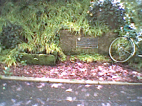
Follow the Greenway bus lane out of Edinburgh, look out for a low bridge and a Texaco garage ahead, turn left before the garage, going behind the garage, to turn right onto a path taking the right hand path to the top of the embankment. The route is poorly way marked here. The bridge has the coat of arms for the Caledonian Railway Company incorporated into the ironwork.
 Caledonian Bridge iron work
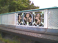
Point to note, after Cramond Brig the route uses a shared use footpath which goes against the flow of traffic, stay on the footpath when climbing the hill. An interesting curio can be seen on the wall at the end of the slip road, opposite the Vehicle Weighbridge and before the bus shelter. Two holes in the wall my not seem much, but on closer inspection they are actually rifle ports, made presumably as a local defence measure to cover the entrance to the army headquarters at Craigiehall during WW II.
 Gun loops
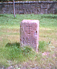
Beyond the bus shelter is a large cylindrical sandstone mile post with a weathered inscription "Edin" and a surveyors mark at the base.
 Mile Marker
The last variation on the route is after the A90 where the NCN 1 follows the slip road towards South Queensferry, leave the shared use footpath at the bus shelter, turn left, going across the road, turning right onto the cycle lane., at the top of hill, turn left using the dedicated cycle lane going towards Dalmeny.
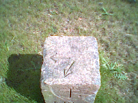
The last curio, while not strictly on this route description can be found at the end of the slip road for Inverkeithing. At the roundabout, opposite the Park-and-Ride facility is a square granite block, with an anchor and No.6 engraved into the stone. This admiralty boundary marker stone was originally across the road near where the gate and was used to mark the land boundary of the Rosyth Naval Dockyard.
 Admiralty boundary stone