
![]()
![]()
![]()
![]()
![]()
![]()
![]()
![]()
This section covers the 38 km / 24 miles from Arbroath to Dundee. I would have liked to had done this route south to north but circumstances dictated otherwise.
The route crosses the busy A92, three times and each
time gets harder the closer you get to Dundee.
Some dodgy roads are used in Dundee, when quieter ones are available –
it's a mess in the city centre.
Go through the the docks, its easier even though the Forth Ports Authority forbids cycling through the docks it is still safer than East Docks Street.
Back
Arbroath – starting from the Signal Tower Museum, turn left at the Millennium Sign Post and continue along the sea front, passing behind the football stadium, through the car park and along the esplanade.
Follow the road around to the right at the night club, then turn left going into the play park. Turn right at the end of the play park to go under the railway line, there is an awkward ramp to negotiate. Turn left and continue along the busy A92 for a short while. It is not clear if the footpath on the far side is shared use or not.
Turn right at the mini roundabout at the McDonalds, no advance warning of the turn. Turn right and continue up the hill. There is a segregated use footpath outside the restaurant, which becomes a cycle lane on the road. The way marking signs for the south bound route is to the right, which makes them difficult to follow.
Turn left into Arbirlot Road West, no advance warning of the turning. The road surface at the top end of the road is badly cracked making unpleasant cycling. Turn left at the T-junction with East Muirlands Road.
Go through Arbirlot, cross a bridge and go up a short hill to a T-junction then turn left. Then turn right and continue in front of the row of houses. Turn left at the T-junction, at the end of this road, and follow the road around to the left and then left at the next T-junction which will lead down to the A92.
Turn left onto the A92 and then right signposted for
Hatton, exercise great care. At the bottom of this road there are a number
of small aircraft hangars from the former wartime RNAS base. Follow the
road around to the right, at the end of this road turn left heading to
the sea, then follow the road around to the right as you enter East Haven
to run parallel with the railway line. Pass by Liz McColgan’s Health
Club before entering Carnoustie, the main road forks to the right to come
up to a T-junction at Carlogie Road, turn left and continue all the way
through Carnoustie. A Millennium Signpost is on the left land side.
Follow the road through Barry. Turn right shortly after passing a church
on a sharp left hand bend and go up the short hill behind the church.
Follow the road around to the left and left at the aerial mast.
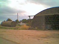 East Haven, aircraft hangar
Cross the A92 carefully and turn left a short while later. A point of interest can be found at Carlungie Farm. On the left and not signposted from the road is Carlungie Earth House. There is a sign for the earth house down the farm road, which directs you to across the field to the right. The earth house is in fact an underground cellar or store usually built alongside a dwelling.
Re-trace your tracks back to the road and turn left awhile later you will come to a staggered cross roads near Newbigging, turn right then left onto the B961 for Kingennie. There is little or no warning of the next turning after Kingennie it is a staggered junction, turn left sign posted for Ethiebeaton and Monifieth.
At the end of the road you’ll come up to the A92 and the busiest of the three crossings. There is no indication that you should use the shared use footpath to the right. Cross straight over and turn left to go down a footpath, beside the parapet of a redundant railway bridge. The footpath crosses a farm road and then follows a new course due to a spate of house building to run parallel with the A92.
The new path then turns sharply to the left to go up a slope to join a road. Half way up the gravel surface stops and a tarred surface begins, which presents a very sharp edge and puncture hazard.
At the top there is no indication of where to go. I turned left and found the route on the right after the entrance to Lawers Avenue. The unmarked path follows the old railway line between the houses to the Dichty Viaduct.
On the far side the footpath falls away sharply to come to a cross roads with a Millennium Signpost. Turn left and follow the lane between houses and school. At the bottom turn right into East Navarre Street, then turn left into North Balmossie Street and descend to the junction of the A930. Cross straight over into South Balmossie Street, to go over the railway, using the footbridge.
After crossing the railway, turn left and continue along the path beside the railway line. The next junction is unmarked, turn left to follow the track beside the children’s play park. Go through a chicane barrier and turn left to join the road along the seafront. This road has a fair number of speed bumps.
At the castle, follow the road around to the right, keeping it to your left, turn left after the bowling club and when you reach the river follow the road around to your right.
A short distance along the riverside you will come to the RNLI Lifeboat Station, on the wall is memorial to the crew of the Mona, which was lost with all hands, 8th December 1959.
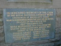 Mona lifeboat memorial, Broughty
Ferry.
Mona lifeboat memorial, Broughty
Ferry.
The next turning is not all that well way marked, turn left following the riverside path, keep the river to your left and you can’t go wrong. This path passes a number of sailing clubs and ending shortly afterwards.
The way marking here is poor: the route turns sharply to face onto a car park and your attention is wholly taken up with avoiding the kerb, cars or pedestrians. Follow the path to the left and when suitable join the road. A short distance later, the road will split, the way marked route will turn away from the river and cross a railway bridge, while another road will fork to the left. This left hand route passes though the docks and forms a shorter and quieter alternative to the way marked route.
From here on the route “sucks” it uses too many busy roads and junctions. Continuing the way marked route crosses the railway line to come to a busy roundabout, go straight on, turning into Strips of Craigie Road then turn first left into Craigie Avenue.
The avenue climbs gently but constantly up to a busy
roundabout, a small square “1” sign to the left of the church
on the far side of the roundabout is the only indication of where the
route goes, cross over the roundabout and continue along Craigie Avenue
still going uphill. The climb ends at a T-junction with Arbroath Road
at a cemetery, turn left and continue. The footpath to the left is a shared
use footpath, though I did not see where it started, nor where it ended.
A cycle lane begins before the junction turn left and go down what is
Princess Street. At the traffic lights, cross straight over and go into
a “No Entry
Except for Busses, Taxis and Cycles” road. The way marking here is
a bits of a dogs breakfast, follow the road around to the left into St.Andrews
Street, do not enter the pedestrian precinct!
At the next junction cross over into Trades lane and turn left at the bottom onto a very busy road. The footpath to the left may be shared use, though there are no signs to say it is. Cross the busy road at the pelican crossing and use the footpath to the left.
There is a better alternative to the next part of the route, after the pelican crossing continue on the footpath, turn right, then left to run parallel to the dock and new hotel building, at the end of the road cross over and then turn right into the Bridge Authority car park. The route continues at the lift under the bridge.
Otherwise, turn left after the pelican crossing, down the dropped kerb, no dropped kerb on the far side, pass alongside the old Customs House and follow the path alongside the approach for the Tay Bridge to a junction, cross straight over and sharp left onto the footpath, then right to go through the car park under the bridge to the glass fronted lift entrance.
National Cycle Route 77 joins NCN1 from the right and there is a Millennium signpost between the Swimming Pool and the RRS Discovery.