
![]()
![]()
![]()
![]()
![]()
![]()
![]()
![]()
Like most airports, Glasgow airport is only “geared-up” to one form of transport – aircraft, everything else is an after-thought and if there is ever such a thing as an after afterthought then cycling to Glasgow Airport is it!
This cycle route is tacked-onto the normal airport roads, any traffic free parts of this route are piece meal and poorly though out. Welcome to Glasgow Airport, the gateway to the west of Scotland!
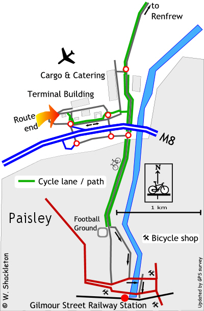
Airport to the station
Leaving the terminal building, turn right and wheel your bike along the foot path. At the “Pelican” Traffic light* cross the road towards the small multi-story car park, passing by a set of cycle lockers then follow the red painted cycle route on the footpath.
Caution – the painted surface may present a skid risk, allow greater time for braking.
The cycle route crosses the exit for the car park and continues along the footpath heading towards the M8 motorway (no cycles) and a roundabout. Just before the roundabout a “mandatory” sign advises cyclists to dismount, however it is up to you if you do.... Cross the road, the cycle lane on the far side is bi-directional the along a one way street. This may be slightly unnerving to anyone on the “wrong” side of the road heading towards the oncoming traffic.
Shortly afterwards the cycle lane passes a car hire garage and a large sign proclaims the end of the cycle route, however the cycle lane continues onwards before turning left to mount the footpath, crossing the entrance to a car park then continues for a short distance to a very busy road. There should be a “pelican” crossing at this point but there is not. When safe cross the road and continue along the cycle lane marked out on the footpath.
The cycle lane crosses the main road into the cargo and catering areas at a 90° bend in the road, not a good place to cross. Cross directly over and continue along the segregated use footpath* (pedestrians and cyclists have separate parts of the footpath) for a short distance before coming to a busy road junction.
Keep left!
From an international point of view the one thing that is lacking from this route is a cycle on the left sign at this junction. There are a few multi-lingual signs for the motorists just before the motorway but nothing for cyclists, who will not have had to cycle on the highway until this point.
Cross directly over, and follow the advisory cycle lane* along the road to your right heading towards a roundabout (and Paisley). At the roundabout continue straight on passing some small air cargo sheds and the HM Customs & Excise offices.
As you approach the football ground (St. Mirren Football Club), the cycle route turns off to the left heading down a small side street with a sharp bend at the end. A small patch of cobbles, setts or pave’ presents its self for your enjoyment. Follow this road all the way to a very busy road junction.
Turn left ( it is a one way street), cross the bridge and turn right at the traffic lights. It may be prudent to use the Pelican crossing at the lights and wheel your bike across. A shared use footpath continues past a church to come to another busy road crossing. A sign advises you to cross using the lights. Cross over and continue with the traffic to another set of lights, go straight on and shortly afterwards is the main entrance for the station.
I expect that there will be a lift available otherwise you will have to carry your bike up several flights of stairs.
Station to the airport.
From the main entrance of the station, cross the street at the lights and wheel your bike down the one way street. At the end, cross this very busy road and continue along the road almost opposite. Follow and the route signs for Glasgow Airport.
Pelican Crossings
This is the name given to the pedestrian controlled crossings. (The dedicated version for cyclists is called a “Toucan” crossing with a push button unit at a convenient height for cyclists.) Activating a button will cause the traffic signals to stop the traffic. Cross when the red man changes to green. A warning beeper will sound towards the end of the stop lights phase to alert you that the lights will change.
Shared Use Footpath
It is not permitted to cycle on any pavement or footpath,
unless the foot path is designated as a shared use footpath or a segregated
use footpath. A shared use footpath is denoted by blue sign with a man
standing above a cycle. A segregated use footpath is denoted with a man
and cycle side by side separated by a while line, which corresponds to
a continuous line on the footpath. A cycle symbol on the footpath denotes
which side is for cycles. Note: pedestrians are free to use any part of
a segregated use footpath they
feel like using.
Cycle Lanes
Cycle lanes are usually marked by a continuous or broken white line along the edge of the carriageway, about one metre from the kerb. An advisory lane (broken white line) is just that, it is not compulsory to use this lane, e.g., rough road surface, grit, glass, Irn Bru cans, pot-holes etc. A continuous or un-broken white line is a compulsory cycle lane and you should not stray over the line. Note: Cycle lanes may be painted red or green, which does not mean anything except the council had some spare money left over at the end of the fiscal year.
Yon bonny banks
If you are heading for the bonny banks of Loch Lomond, consider the route through the cargo and catering area, turning right opposite the British Airways hangar and left at the roundabout. The footpath along Inchinnan Road is designated as a shared use footpath. At the top of the road turn right and follow the signs for Renfrew Ferry (small charge for the crossing) or turn left for Inchinnan, Erskine and Erskine Bridge (cycles cross for free.)
Heading west
Follow the cycle route into Paisley and try and pick up the National Cycle Route number 7 (Ayr and Carlisle) or 75 (Greenock), for mostly traffic free routes. It is best to obtain a map from Sustrans before traveling on these routes.