
![]()
![]()
![]()
![]()
![]()
![]()
![]()
![]()
Part 2: Ballinluig to Pitlochry
This is the second part of this 47 km / 29 mile route
This route is not easy as it involves a number of hard climbs; notably
the one up to Dalcapon and in Craigvinean Forest you have to push your
bike up path for 170 m between two forest roads.
All said and done I found it to be an enjoyable run. The beauty of this
route is you can cut out the real hard part by only doing the first part.
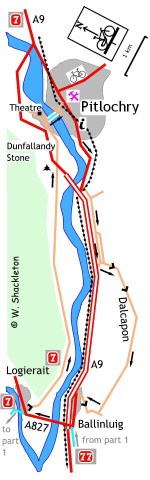
Turn left onto the A827 to Logierait , shortly after entering Logierait, NCN 77 joins NCN 7, the Carlisle to Inverness route, continue on for a short distance, then use the shared use footpath opposite the Logierait Hotel, going up the hill to the junction and turning right. Alternatively turn right off the main road and go up the short, steep hill onto a narrow undulating road heading for Pitlochry.
Just outside Pitlochry is the Dunfallandy Stone. A Pictish cross, carved on a stone slab around the 9th century. The stone used to stand in a churchyard in Killiecrankie before being moved to its present position at the end of the 19th century. To get to the cross, turn left at Dunfallandy Farm, go over the cattle grid and up the short hill, leaving your bike at the foot of the steps for the hilltop burial ground. The cross is protected from the elements by glass panels and may be difficult to see in wet weather.
Continuing, go underneath the A9 to come to a T-junction alongside the caravan site and turn left. The next signpost is missing, which is a right turn just before the Festival Theatre. Turn right, sign posted "Port-na-Craig Historic Hamlet" and go down to almost the bottom of the hill and turn right into the narrow lane.
Cross the Tay using the suspension bridge, there is a warning notice not to cycle on the bridge, which unfortunately is partially obscured by branches.
On the far bank is a sculpture of a fishing boat made of wire, like a kind of like a water going shopping trolley, continue up the footpath to the road and turn right.
Follow this road up the hill past the highland show ground to the traffic lights at the railway bridge, then to the T-junction with the main street beyond and turn left for Inverness or right to return to Craigvinean. Finding yourself in Pitlochry after the peace and quiet of the country roads can be a bit of a culture shock.
The return to Craigvinean.
Turning right at the main street, follow the road out of Pitlochry heading
south for Perth. A Steel Spider sculpture of a woman pushing a pram can
be seen just before the railway bridge and another further on is outside
the local mail sorting office is of an old fashioned postman riding an
Ordinary bicycle, see if you can spot the little spider inside the sculptures.
Just before you get to the A9 turn left going under the railway onto the old A9. Follow this quiet road for a short distance before it too meets the new A9. The Tayside Region, Perth to Inverness route advises cyclists to dismount at this junction. How come there are never any cyclists re-mount signs and why dismount in the first place?
A Pitlochry Cycle Routes green arrow and a "No access to A9 South" signs mark the left turn for Dalcapon, turn left for the start the long climb. At the next T-junction turn right, continuing the climb. The compensation for the exertion is the views. On a good day the views up the glen is more than breathtaking, pity the motorists down below missing all this beauty and exercise!
Half way down you come to a T-junction, turn right, following the green arrow to begin the serious part of the descent into Ballinluig. Shortly after passing the school you come to a T-junction, turn left onto the old A9 for the final time, pass the service station to come to a T-junction. Turn left for Logierait, joining the route of the NCN77 once more.
Entering Logierait turn left immediately after the "Reduce Speed Now" sign, this junction is poorly sign posted. This was once an old railway and now forms a community short cut across the Tay. The road has been re-surfaced and it is marginally better than before. It is rougher still on the far side of the Tay. From painful experience, it is best by far to cycle along the edges rather than the central portion of the bridge.
On the far side, follow the track around to the left and up the short, steep hill to a T-junction to turn left heading away from NCN7. Follow this quiet country road until it almost meets the A9 and turn right onto a forest road for the Newton Craig car park. Go around the gate and on the bend in front, at the brown marker post for the Inver Walk, dismount and wheel the bike uphill for 170 m to a grassy forest road, follow this road to the T-junction, turn right then immediate left.
A blue cycle route marker is just beyond this junction, farther on to the left is a folly called 'Torryvald' named after the remains of an old settlement nearby of that name and was constructed in 1996 on the remains of an older folly previously built upon the rock (possibly by navvies constructing the railway?) The new structure was built by Kevin Blackwell after a design competition and was funded by the Scottish Arts Council. Turn left at the next T-junction, following the blue coded marker post back to the starting point.
My thanks to Peter Fullerton for the Craigvinean shortcut.