
![]()
![]()
![]()
![]()
![]()
![]()
![]()
![]()
The full 47 km / 29 mile route to Pitlochry and back route is not easy as it involves a number of hard climbs; notably the one up to Dalcapon and in Craigvinean Forest you have to push your bike for 170 m up a connecting path between two forest roads. So if you do not like climbing then I would suggest returning to the starting point from Logierait where you have only the forest path to contend with. All said and done I found it to be a most enjoyable run.
This route uses parts of two out of the three versions of the A9 Edinburgh - Wick Road; the military road which was a tarred over version of the original dirt track and the later improved road which itself was superseded by the modern road we use today.
My route starts from one of the car parks just off the A9 for the Hermitage; both the National Trust for Scotland car parks are Pay and Display however up the road the forestry car park is free, any of these car parks will do.
Part 1: Dunkeld to Logierait
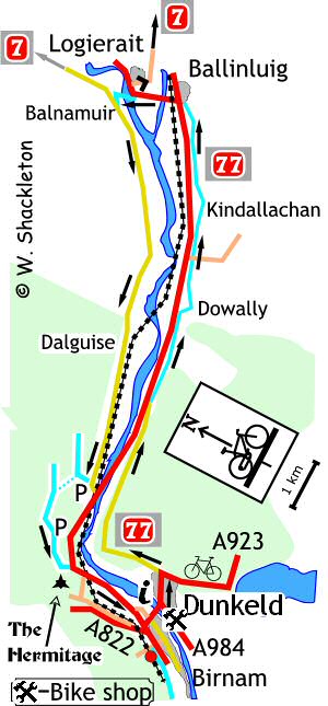
Leave the Forest Enterprise car park and go back down
the reasonably well-surfaced forest road back to the A9. At the bottom
of the road use the footpath to the right running alongside the slip road,
which leads to Inver, cross the bridge over the Braan and turn left onto
the old military road. (General Wade got all the credit for the network
of military roads that criss-crossed Scotland following the 1745 rebellion,
however it was General Wade's troops that done all the real work!)
Turn left onto the footpath, just before the council depot, sign-posted
for Birnam & Dunkeld via underpass following the path under the A9
and around to the right, turn right onto the minor road at the T-junction
and left at the junction with the main A923 road, (which was the old A9)
and over the Telford Bridge into Dunkeld.
Go all the way through Dunkeld, there are toilets in a large Pay and Display car park, which is also the entrance to the ruins of Dunkeld Abbey.
The sign posted NCN 77 starts at the junction with
the A923 Blairgowrie Road.
Continue along the route of the old A9, a small standing stone can be
seen in the field to the left opposite a small loch and farther on and
to the right is the Craig a Barns rock face which is popular with climbers
learning the ropes.
Just after the small car park for the crags is a little rockery garden with a memorial plaque, in memory of Allan Calder, 1933 to 1998, beside his beloved North Road.
You begin the descent good views of the Jubilee Bridge and the Tay can be had from parts of this road.
At the junction with the new A9, there is a segregated "jug-handle" junction to connect with the new-shared use footpath on the right. Cyclists are supposed to go onto the footpath on the left then directly cross the road, instead of turning right in the conventional manner from the middle of the road. Unfortunately all this effort is wasted, as there is no fore warning of this facility as you approach the junction.
The shared use footpath is luxuriously surfaced with smooth tar, full credit has to be given to the Perth & Kinross Countryside Trust, who undertook the work on this path.
At Dowally, the footpath crosses a minor road and continues between the A9 and the church descending to rejoin the old A9, to the right is a craft shop and restaurant. Turn left and follow this road until it comes to the new A9 and another segregated "jug-handle" junction or turn right onto the shared use footpath.
Another minor road is to be crossed at Guay Farm continue along the shared use footpath then turn onto the military road, a notice advises cyclists to look out for cars and pedestrians on this section of road.
The military road comes to Kindallachan where you turn right onto the old A9, going through a gate with confusing "No Entry" and cycle route signs.
The military road joins the old A9 at the top of the hill and they run parallel with each other for a short distance before joining and descending to the A9 and another section of shared use footpath.
Cross the Ballachallan Farm road end and continue along a leafy section of the military road, joining the old A9 shortly afterwards. Note that this next section will be built over as part of the Ballinluig Junction re-alignment. A fence and gate has been erected across the road, go around the gate and continue along the old A9.
Continue to the bridge then go up the embankment to
join the A827 turning left for Logierait.
Shortly after entering Logierait, NCN 77 joins NCN 7, the Carlisle to
Inverness route, the way north continues in PART TWO.
If you wish to return to Inver then - on entering Logierait turn left immediately after the "Reduce Speed Now" sign, this junction is poorly sign posted. This was once an old railway and now forms a community short cut across the Tay. The road has been re-surfaced and it is marginally better than before. It is rougher still on the far side of the Tay. From painful experience, it is best by far to cycle along the edges rather than the central portion of the bridge.
On the far side, follow the track around to the left and up the short, steep hill to a T-junction to turn left heading away from NCN7. Follow this quiet country road until it almost meets the A9 and turn right onto a forest road for the Newton Craig car park. Go around the gate and on the bend in front, at the brown marker post for the Inver Walk, dismount and wheel the bike uphill for 170 m to a grassy forest road, follow this road to the T-junction, turn right then immediate left.
A blue cycle route marker is just beyond this junction, farther on to the left is a folly called 'Torryvald' named after the remains of an old settlement nearby of that name and was constructed in 1996 on the remains of an older folly previously built upon the rock (possibly by navvies constructing the railway?) The new structure was built by Kevin Blackwell after a design competition and was funded by the Scottish Arts Council. Turn left at the next T-junction, following the blue coded marker post back to the starting point.