
![]()
![]()
![]()
![]()
![]()
![]()
![]()
![]()
This route covers 20 km / 13 miles from Killiecrankie to Dalnamein Lodge. The cyclist will travel from the enclosed Pass of Killiecrankie to the bleak-ness of northern Perthshire.
A notice at Calvine warns of the changeability and the potential seriousness of the weather in this part of the highlands. This warning should not be taken lightly, apart from a handful of farms there is nothing between Calvine and Dalwhinnie.
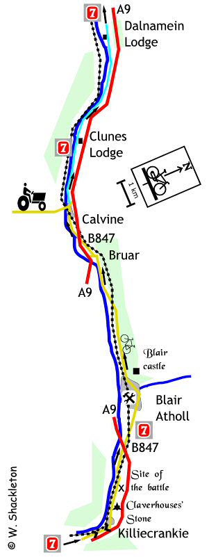
At the head of the Pass of Killiecrankie is a National Trust for Scotland Visitor Centre which tells the story of the Battle of Killiecrankie which took place on 27th July 1689 in this wooded gorge. Here, a Jacobite army led by John, Graham of Claverhouse "Bonnie Dundee" charged the Government forces under General Hugh Mackay from high ground.
The government line broke and the Jacobites began a rout toward the River Garry. The victorious Highlanders did not know that their leader, Dundee, had been mortally wounded. They had lost 900 men while the Mackays' overnment army lost 2,000 men, half his force.
Unfortunately this was a case of winning the battle but losing the war as, without their leader, the Highlanders were lost and went on to eventual defeat at Dunkeld.
The 8% descent from the Visitor Centre means that you shoot through the village without hardly noticing it and before long you are out in the countryside with the A9 and railway for company once again.
Just after the village in the field to the right is Claverhouses Stone, where Dundee is said to have died.
Continue along the road going under the A9 onto a busier and narrower road into Blair Atholl.
Jim Stewarts Bike shop is tucked away to the left, just after you cross over the River Tilt.
Continue through the village and back out into the countryside, Blair Castle can be seen to the right. The road ahead is flat and straight all the way to Bruar. This is probably the last piece of flat ground for a while so make the most of it as the slow climb to the head of Drunochter Pass begins soon.
Bruar has a picturesque waterfalls and the not so picturesque
House of Bruar shopping experience. After passing the House of Bruar turn
right immediately before the A9 onto the B847 to Calvine, this junction
is poorly way marked.
The long climb to the top of the pass starts as you go under the railway
bridge and will seem to go on forever.
Go through the village, the local garage had a compound to the left which was always full of wrecked cars from crashes on the A9, thankfully there are not so many these days.
A warning sign opposite the Struan Primary School should be read and the consequences understood before going any further - "Drunochter summit cycle track climbs to 457 m (1,500 feet), weather conditions deteriorate without warning and can be severe even in summer. No food or shelter for 30 km (19 miles). No snow clearance or gritting on cycle track."
Just after passing through the halves of a stone sculpture (supposed to symbolise a musical instrument bringing together the communities of Calvine and Dalwhinnie,) you go onto the old A9, which is still used by the locals though deceptively quiet. The road ahead is brilliant, heavily wooded with Scots broadleaf trees, well surfaced and quiet, it is a pity that it does not last long, shortly after Clunes Lodge the scenery opens out to fields and hills and unfortunately the elements.
About 2 km or 3 miles from Clunes Lodge you cross a burn using an impressive pre-stressed concrete bridge, now only open to cycle traffic and not far after that is a ruined croft and telephone exchange which, if you should need it provides a welcome break from the wind.
Ahead is Dalnamein Lodge, continue past the lodge on the old A9.
Further reading...
A very in depth account of the battle
A Personal view of the battle and a more readable version