
![]()
![]()
![]()
![]()
![]()
![]()
![]()
![]()
This route gives the opportunity to link the Perth to Inverness Cycle route to the city centre, without putting your neck on the line.
Using a mix of quiet roads and a track along the flood prevention barrier a safe quiet route can be found right into the city centre, 9 km or 5 miles.
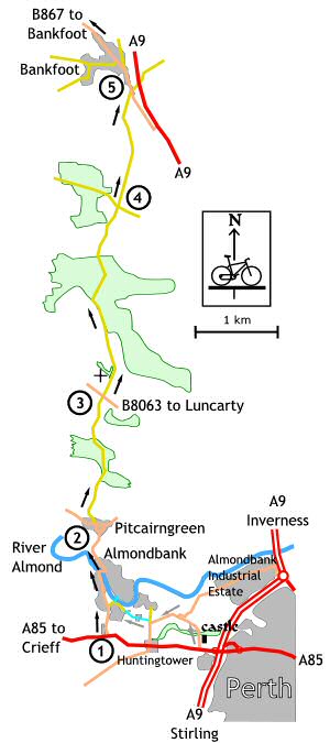
Way before Sustrans started laying down routes all over the country, the predecessor of Perth & Kinross Council devised a route to safely channel cyclists away from the A9 Road.
A number of cyclists have been killed on this busy road and the initiative to draw cyclists away from the A9 was very welcome. Unfortunately the route is not sign posted in Perth and the only way that a tourer will find this route is to stumble across it whilst cycling on the A85 Road, which is at times a busy and not a cyclist friendly road.
Assuming that you have fought your way out of Perth, the climb along the A85 out of Perth towards the A9 by-pass is not much fun. The good news is there is no other climb as bad as that, the not so good news is there are two shorter climbs ahead at Almondbank and Pitcairngreen.
I would recommend using the diversion route, shown with grey arrows that passes by Huntingtower Castle rather than the sign posted route which starts a mile or so farther down the A85. The only drawback with the diversionary route is a short stretch of unmade farm road which can be festooned with large puddles.
Follow the road down the short hill and turn left at the junction, notice the redundant water wheel encased in a brick-walled enclosure, the water course, is the Town Lade which supplied water power to the mills in Perth Town Centre (now the local Tourist Information Centre), follow the lade upstream until the next T-junction and turn right then immediate left onto a farm track.
Suffer the rough surface for a half mile, until returning onto a tarred road beside the River Almond. Turn left and follow the river upstream, and turn left at the bridge to follow the boundary fence of the former Royal Naval Aircraft Yard, (a storage and repair depot) to the junction with the main road and turn right into Almondbank village.
Otherwise follow the A85 towards Crieff and turn right, signposted for Inverness Cycle Route and Almondbank.
1. Turn right, and follow the road through the village, climbing gently until the bridge over the Almond when the gradient becomes more severe. At the top of the hill the road turns away from the river and down a short incline into Pitcairngreen.
2. Pitcairngreen is one of the “undiscovered gems” of Perthshire, looking out of place, more suited to a typical English country village rather than rural Perthshire. Follow the road to the left, then left again. Look out for a small road on the right, turn right and climb up the short steep hill. The house at the top has a private golf course on the front lawn. Now we are finally out into the country- side, the road climbs slightly before descending to the B8063 cross roads.
3. Cross straight over and follow the road past the old church at Moneydie then continue to the next cross roads.
4. Cross straight over, up the gentle climb and down into Bankfoot.
5. At the junction with the B867, turn left and follow this road all the way through the village towards Dunkeld.
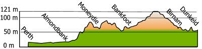 Perth
to Dunkeld profile
Perth
to Dunkeld profile