![]()
![]()
![]()
![]()
![]()
![]()
![]()
![]()
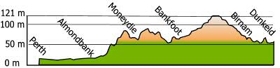
This section covers the 23 km / 16 miles between Bankfoot
and Logierait.
The route from Bankfoot (and Perth) is expected to become the National
Cycle Network (NCN) 77 at some point in time.
NCN 77 has already been established between Dunkled and Logierait where the NCN77 ends and the route to Inverness continues on the NCN 7.
Back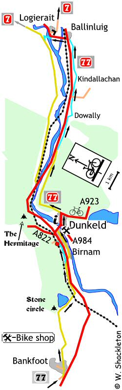
The North Road
This route will use parts of two out of the three versions of the A9 Edinburgh - Wick Road; the military road which was a tarred over version of the original dirt track and the later improved road which itself was superseded by the modern road we use today.
The Military Road.
General Wade got all the credit for the network of military roads that criss-crossed Scotland following the 1745 rebellion, however it was General Wades's troops that done all the real work!.
The route
Follow the B967 road through Bankfoot, which climbs gently, passing through the quaintly named village of Waterloo, no doubt named in honour of the famous battle.
A pair of standing stones can be seen in a field to the left shortly before a large and picturesque loch which also marks the start of the descent to Birnam.A shared use footpath begins close to the junction with the A9, which removes the need to take your life in your hands crossing the A9.
Turn left onto the footpath and continue between the A9 and the railway until you draw close to the signal box, where the footpath becomes a cycle lane, which goes along the slip road for the station then crosses the station car park ending at set of steps.
Wheel your bike down the concrete channel to the road below and turn right and follow this road down to the T-junction.
A small garden to the right of this junction is dedicated to Betrix Potter. It was during a family holiday Birnam that Betrix Potter first wrote what was to become the famous Peter Rabbit stories.
Turn left at the T-junction and continue through Birnam to the T-junction with he main road off the A9 for Dunkeld. Turn right onto the A923 road and go over the Telford Bridge into Dunkeld. A commemorative plaque can be found at the Dunkeld end of the bridge.
Go all the way through Dunkeld, there are toilets in a large car park at the far end of the town. This Pay and Display car park is also the entrance to the Pay per View ruins of Dunkeld Abbey.
The sign posted NCN 77 starts at the junction with the A923 Blairgowrie Road. Note - the NCN signs are aligned to be seen from the Blairgowrie Road and not from Dunkeld.
Continue along the route of the old A9, a small standing stone can be seen in the field to the left opposite a small loch, farther on and to the right and towering above is the Craig a Barns rock face popular with climbers learning the ropes.
To the right, just after the small car park for the climbers is a little rockery garden with a memorial plaque, in memory of Allan Calder, 1933 to 1998.
You begin the descent shortly afterwards; good views of the Jubilee Bridge and the Tay can be had from parts of this road.
At the junction with the new A9, there is a segregated "jug-handle" junction to connect to the new-shared use footpath on the right. Cyclists are supposed to go onto the patch of tar to the left then directly cross the road, instead of turning right in the conventional manner from the middle of the road. Unfortunately all this effort is wasted, as there is no fore warning of this facility as you approach the junction.
The shared use footpath is luxuriously surfaced with smooth tar, full credit has to be given to the Perth & Kinross Countryside Trust, who undertook the work on this splendid path.
At Dowally, the footpath crosses a minor road and continues on the footpath, between the A9 and the church going down to join the old A9, to the right is a craft shop and restaurant. Turn left and follow this road until comes to the new A9 and another segregated "jug-handle" junction or turn right onto the shared use footpath.
Another minor road is to be crossed at Guay Farm continue along the shared use footpath then after the farm, turn off the shared use footpath onto the military road, a notice advises cyclists to look out for cars and pedestrians on this section of road.
The military road comes to Kindallachan where you turn right onto the old A9, going through a gate across the road with confusing "No Entry" and cycle route signs.
The military road joins the old A9 at the top of the hill and they run parallel with each other short a short distance before joining and descending to the A9 and another section of shared use footpath.
Cross the Ballachallan Farm road end and continue along a leafy section of the military road, joining the old A9 shortly afterwards. Note that this next section will be built over as part of the Ballinluig Junction realignment. A fence and gate has been erected across the road, go around the gate and continue along the old A9 to the bridge, go up the embankment to join the A827 then turn left for Logierait.
Shortly after entering Logierait, NCN 77 joins NCN 7, the Carlisle to Inverness route, continue on for a short distance, then use the shared use footpath opposite the Logierait Hotel, going up the hill to the junction and turn right. Alternatively turn right off the main road and go up the short, steep hill onto a narrow undulating road heading for Pitlochry.
Perth to Dunkeld profile