
![]()
![]()
![]()
![]()
![]()
![]()
![]()
![]()
This route covers 35 km / 22 miles from Logierait to Killiecrankie, passing through some beautiful countryside and the busy highland town of Pitlochry to the Jacobite battleground at Killiecrankie.
National Cycling Network (NCN) route 77, which we have been following up from Perth joins NCN 7 the Loch & Glens Route 2, from Carlisle to Inverness.
Back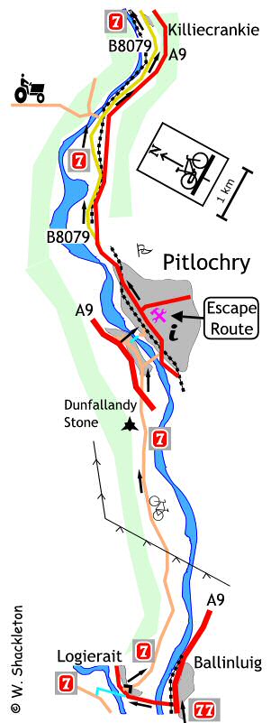
Shortly after entering Logierait, NCN 77 joins NCN 7, the Carlisle to Inverness route, continue on for a short distance, then use the shared use footpath opposite the Logierait Hotel, going up the hill to the junction and turn right. Alternatively turn right off the main road and go up the short, steep hill onto a narrow undulating road heading for Pitlochry.
Just outside Pitlochry is the Dunfallandy Stone. A Pictish cross, carved on a stone slab around the 9th century. The stone used to stand in a churchyard in Killiecrankie before being moved to its present position at the end of the 19th century. To get to the cross, turn left at Dunfallandy Farm, go over the cattle grid and up the short hill, leaving your bike at the foot of the steps to the hilltop burial ground. The cross is protected from the elements by wall and glass panels and may be difficult to see in wet weather.
Continuing, go underneath the A9 to come to a T-junction at the caravan site and turn left. The next signpost is a tatty "7" sticker on a lampost and is difficult to see, turn right just before the Festival Theatre, sign posted "Port-na-Craig Historic Hamlet" and go down to nearly the bottom of the hill and turn right into the narrow lane.
Cross the Tay using the suspension bridge, there is
a warning notice not to cycle on the bridge, which alas is unfortunately
is partially obscured by branches.
On the far bank is a sculpture of a fishing boat made of wire, like a
kind of like a water going shopping trolley, continue up the footpath
to the road and turn right.
Follow this road up the hill past the Highland Show Ground to the traffic
lights at the railway bridge, then on to the T-junction with the main
street beyond and turn left for Inverness. Finding yourself in Pitlochry
after the peace and quiet of the country roads can be a bit of a shock.
One of the best cycle shops in Scotland can be found in Pitlochry, Kevin Grants' Escape Route Shop can be found on the right a short distance up the Moulin Road. Continue through the town following the old A9, which is now the B8079 through the Pass of Killiecrankie. It is not too clear when you leave Pitlochry if the footpath is shared use or not, there are no signs; it just looks like it should be. The footpath disappears completely by the time you get the Fascally restarting as a gravel path, still no signs.
The gradient increases as you get deeper into the Pass of Killiecrankie, there is a 14% climb to get up to the Killiecrankie Visitors Centre and an 8% descent from the centre into the village. I did not stop at the visitors centre, though it does have toilets...