
![]()
![]()
![]()
![]()
![]()
![]()
![]()
![]()
These routes are walkers and cyclists. All the forest roads and a few of the paths can be rode on a mountain bike and for the adventurous, there is a link through to Dunning Glen .
The trees in the first part of the plantation are young, while at Rashie Hill the trees are a lot older some are mature enough to harvested.
Back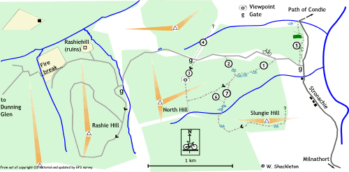
Cyclists
Most of this route is a “there and back” run around Rashie Hill along seldom travelled forest roads.
Leaving the car park near the Stronachy Road, pass through the opening in the gate climbing gently as you go. The top of the climb is marked by a small loch, which in summer may be nothing more than a mucky puddle. After the loch you will descend quickly around the sweeping bend to come to another gate at the entrance to Rashie Hill Plantation. Pass through the gate and turn left, the gradient increases and the road surface may be slimy with moss.
The forest road makes another fork, here a choice has to be made. Going left (or straight on) the road continues to climb to around 400 m mark, going this way will give you a long descent for the remainder of the run back to the fork. Going right, the gradient is not so steep though the climbing is longer and the descent back is a great deal faster! Either ways take care, these roads are seldom travelled and can be slimy in wet weather. From the fork return down hill to the gate at the entrance to Rashie Hill plantation.
The right hand road at the entrance to Rashie Hill Plantation leads past the abandoned farm buildings of Rashie Hill Farm and ends at a dead end. There is a way through into Dunning Glen which may mean pushing or carrying your bike for a short distance before joining a long forgotten forest trail leading to a forest road into Dunning Glen. The trees at the end of the forest road have been recently felled, either look out for the old fire break (shown as a dotted line on the map) or follow the burn down from the dead end for a short distance, until you see a small burn joining from the left. There should be a long forgotten forest trail running westwards along this burn which will link onto a forest road. On meeting the forest road, head to the left going uphill to a junction and a steep descent into Dunning Glen.
At the younger plantation, path “3” offers a steep and difficult climb with a grassy descent back to the forest road along path “2” or continuing north-eastwards along path “1” to the forest road. Heading in the reverse direction would give difficult and strenuous cycling. There is a good view to the north and east from the view point from path “3,” giving a good excuse to have a rest if nothing else.
The remaining paths are not suitable for cycling.
Walking
From the car park, the first path is path “5” which descends past a small abandoned quarry and a clump of mature Scots Pines to a gate alongside the Path of Condie Road. There may be a path westwards which may link onto another plantation to the north.
Path “4” seems to be there, but was not surveyed, it possibly links onto the newer plantation to the north.
Path “6” is not worth the effort, it starts off fine, degenerating into an uneven descent to join path “7.”
Path “7” is the longest, going over a small bridge and a rough path to the top of Slungie Hill. The way markers then seem to disappear leaving you in limbo. The path may head west to loop around Slungie Hill. I cannot advise continuing northwards towards path “1” as it is over difficult walking terrain.