
![]()
![]()
![]()
![]()
![]()
![]()
![]()
![]()
This write up describes five of the paths in the Kinross / Milnathort area which can be cycled upon. They range from the domesticated Davey’s Park path to the contentious Newlands Track.
Each path or track has their merits, each makes for an interesting diversion or a handy short cut.
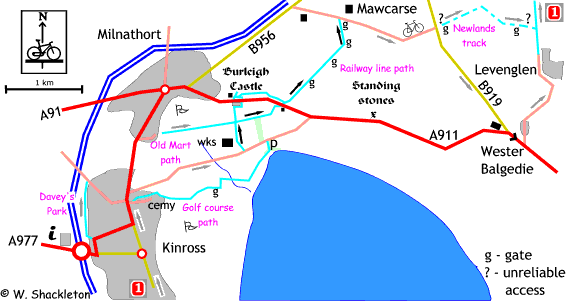
Davies Park Path
The path can be gained from the A-class road (see map), at the right hand bend, turn left and continue along the tarred road past the swing park to join a wide path at the end of the Kinross railway station platform. The path then swings around to the right to follow the fence line. All too soon the path narrows down to a single bumpy, muddy track.
At the end, the path climbs steeply up the embankment onto Gallowhill Road, alternatively, as you approach the embankment look out for an opening in the fence, go diagonally across the grass to join Gallowhill Road. Either way, turning right will lead you onto the main Kinross - Milnathort Road, turning left leads over the M90 and into the countryside.
Golf Course Path
This one may not be to everyone's taste, better suited for mountain bikes as the path can be narrow, muddy and covered in tree roots, however it does provide an alternative to the Kinross - Kinnesswood Road.
Head out of Kinross towards Milnathort, take the second road on the right after the Muirs Inn, turning into Sunnypark Road. Turn left after the house and go through a set of gates to connect with the path following the burn. This path is not too bad, though one has to be wary of the occasional clutch of “dog-eggs.” Follow the path all the way to a narrow gateway in the wall, go through the opening and turn left, following the sign for Burleigh sands.
The path now skirts along the side of the golf course and as ever when near these green artillery ranges be wary of wayward balls. Under the Beech trees the path broadens out before a muddy path to arrive at a magnificent set of gates.
Go through the small inset gate then turn right to go through another, more modern gate onto the “new” path. Follow this path around the the left, and along the banks of the Queich, before turning right to go over a wooden bridge. The path heads for the loch shore before turning right and crossing several wooden bridges to arrive at the Burleigh Sands car park.
I may be telling my ancient relative how to suck hard-shelled objects laid by hens, but take care with these wooden bridges, a bit of moss or algae and you’ll find yourself skidding into a water filled ditch.
Turning left at the car park will lead you back into Kinross and the railway line path (and Kingdom Cycle Route) or turning right will lead you to the A911, and Kinnesswood.
Old Mart Path
Some of this path has been swallowed up by a new housing development, though access is still maintained through the houses. As you enter Milnathort from the Kinross - Milnathort Road, turn right into Auld Mart Road, (the local cattle market used to be to the right.) Follow the road past a modern office block and a storage yard, looking out for a gravel path almost straight ahead.
Follow this path past some houses onto the bed of the old railway. The path degenerates to a rough single track path and again more suitable for mountain bikes. The path passes alongside the golf club and over a wooden bridge to connect with the Railway line path. Turn right and follow the farm track, will lead around the steadings to join with the A911 road at Burleigh Castle.
If you turn left, and just before the castle turn right onto the road for some cottages, then immediate right into the Kinross Community Woodland. Follow the path, up to the left, it may be a bit slippy in wet weather. The path goes down an exhilarating dip before joining a farm track at a small forest, follow the track to the right then to the left along the hedge to join with the railway path.
Newlands Farm Track
This is a contentious route. It is hoped to be able to use this track as part of the Kingdom Cycle Route, otherwise it is an excellent access route onto the Dryside Road.
There are efforts to establish this as a right of way, and as a result this track was closed for a while. The landowner has appeared to relent and allow restricted access to cyclists and pedestrians and even then only during times that no shooting is going on. The warning sign at bottom of the track is displayed in such a manner that a person has to go out of their way to read it, this is especially so during the times when to big gate is open, there is not much point in having a sign and no one being able to read it. At the time of the survey, a second sign notifying of the tracks closure had been consigned to the undergrowth.
The track is not a thing of beauty, assorted pieces of farm yard junk, ranging from a derelict JCB to rubble are strewn along the length of this track. Halfway up, the track becomes muddy and rutted, the final part up to the top gate is not too bad. The best thing about this part of the track is the view of the loch, especially on a summers day.
Another gate, NOTE, one half of the large gate is topped with barbed wire, there is a pedestrian gate to the right. The warning notice is more prominently displayed here.
A short stretch of farm road leads onto the Dryside Road and the Kingdom Cycle Route. Turning left will take you to Strathmiglo, while right will lead to Kinross.
Railway path
The Railway Line path was improved as part of the Kingdom Cycle Route, the path starts off the Kinross - Kinnesswood road at the Milnathort Wastewater Treatment Works, turn left and follow the track heading towards Burleigh castle.
At the cross roads turn right and follow the track, through the access pillars and census point up to the A911 road.
Stop! Traffic can be a bit fast at this point on the road, when safe cross straight over and down the embankment to re-join the old railway. Follow the path through two sets of gates, go to the left at the end of the old railway, and through another set of gates to meet with a final set of gates at Mawcarse.
NOTE: Compared to the West Fife Cycle Way in Dunfermline this path is a bit on the bumpy side. The most important thing to bear in mind that this is a permissive right of way, the path is used by the landowner for access to his fields.