
![]()
![]()
![]()
![]()
![]()
![]()
![]()
![]()
Caution: Forest operations seem to have resumed at the northern (red route) and western (Green rec- reational route) ends of the forest some of the roads are rough and well chewed. Be vigilant for vehicles!
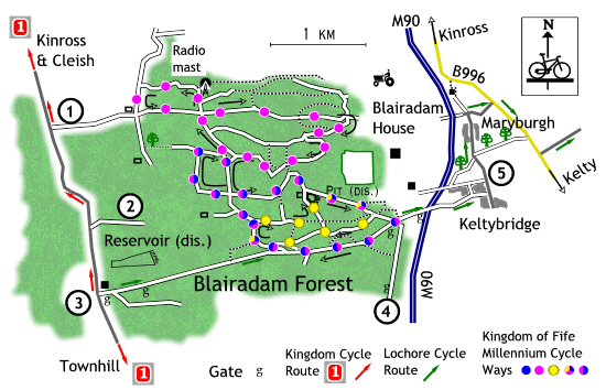
Four routes:
Red Hardest and longest.
Blue Shorter than the Red route.
Yellow Shortest and easiest route.
The Lochore Recreational Route runs from Lochore through Blairadam Forest to connect the main Kingdom of Fife Cycle cycle route to the Millennium Cycle Ways in Blairadam Forest.
Mud!
These routes have all suffered in one way or another from recent forestry operations. Blairadam is great if you like mud, so unless the damaged roads are resurfaced I would not recommend these routes for family groups, indeed all routes are uphill, the severity of the climbs never fails to knacker me!
The start.
All routes start at the south-east corner of the Forest. There are two ways to get there, one from the B914 Kelty to Saline Road and from Keltybridge. It is not possible to park at the starting point anymore. The closest parking place is at the old forestry stores depot at the foot of the road off the B914, however the best places are in Keltybridge (park considerately) or near the houses about half way down from the B914.
The route leads into the trees and takes the first left, after the bridge, into “the Glen,” then follows the burn uphill, passing a large brick block, which was once the support pillar for a railway bridge built to service the nearby pit. Towards the end, of the road turns away from the burn, steeply climbing amongst the trees.
The yellow route then connects with the Red and Blue routes at a T-junction. Turn right, onto the well surfaced path. Follow the path over Pierre's Burn Bridge, which has been closed to vehicular traffic by the erection of a set of crude, hideous and uncyclist friendly barriers.
On the far side of the bridge, the road surface is on the rough side, never having recovered from previous forestry operations. There is an almost overgrown track to the left which leads to the abandoned Lochgelly Town Council water filtration beds, a difficult track and unless you are really "into" municipal water works not worth the effort.
The road ends at a T-junction, the yellow route turns to the right, while the Red and Blue continues to the left. The yellow route uses a grassed over road until it ends at a fire break, and then continues on a muddy track down hill to another T-junction.
If you like a clean bike and clothes, then you will be careful at this junction, the mud is expansive and in places as deep as your bikes wheel hubs - I know! The route turns left and joins the bed of the of railway mentioned earlier, the final part of this route leads to the site of the Blairenbathie Pit, a concrete foundation and a small coal bing are the only reminders of this pit.
The next turn is not marked at the time that I surveyed this route (probably due to the pile of trees trunks awaiting collection,) turn right to rejoining the Red and Blue routes, continue all the way down hill over the bridge and back to the starting point.
Starting from the south-east corner of the forest it continues uphill, through a set of gates following the Lochore Recreational Route. To start with the surface is tarred gradually changing to a reasonable forest road. Near the top, the road crosses an open area which is believed to be the site of a coal mine. The old railway crossed the road at this point and has been recently been adopted as a footpath, continue uphill, passing a road on the left, look out for a widened “parking area” and the marker post on the right.
Take the path on the right and continue over Pierre's Bridge to the T-junction, this time turn left. The surface of this track is hard, rough and in places trenched by water flows. The pedaling gets harder as you make your way uphill . The road emerges at a cross roads with a bewildering marker post, partly due to the number of route arrows and partly because it was lying on the ground, having recently fallen over.
Turn left, the road surface degenerates because of previous forestry operations and erosion. At one point the road is surfaced with bricks (from the nearby defunct Kelty Brick works.) At the top turn right, the road surface at this point is dire; deep muddy puddles and ruts awaits you.
At the end of this road is a T-junction, the Red route turns left and uphill while the Blue route turns right going back down to the cross roads with the bewildering marker post, this time turn left and follow the road down hill. The view from this road has been improved since the tree felling, views of Lochore Meadows and beyond can be had from here. Continue all the way down past to the coal bing to connect with the unmarked Yellow route back to the starting point.
From the point where the Blue route turns right to go down hill, the Red route turns left and heads uphill for the final time.
Continue all the way to the cross roads at the top which is surfaced in large uncomfortable stones, almost boulder like. Cross straight over and passing the radio mast, the route from the mast onwards becomes dire, care should be taken at this part of the route, deep ruts and muddy puddles await you.
The route emerges out of the trees at another T-junction, turn left and up hill to the ruined cottage, turn left, go around the gate and back into the trees. This used to be a good road, it again has suffered under the wheels of the lorries.
Back at the cross roads, continue straight on following this road all the way to the bottom, then turn right and continue to an unusual three way junction, keep to the left and onto another muddy road.
Follow this road, as it turns back on itself, before heading uphill. A short cut is available, for those wishing to avoid the muddy climb ahead, look for a gap in the trees, sometimes awash with water which crosses the road, turn left and follow this small “fire break” down to the next road then turn left, going downhill at the bing. Otherwise continue uphill, again the road has suffered mainly soft mud and ruts. At the top, turn left and go down hill, joining with the Blue route, down to the cross roads, left and all the way down hill to the start.
The route passes the starting point and follows the Red and Blue routes uphill, around a Forest Enterprise gate, past the turn off for the Red and Blue routes and all the way up to the next gate, take care here and at the next gate when going around it is easy to drop into a ditch. The main Kingdom Cycle route is ahead. Turning left will lead to Dunfermline while right will lead over the Cleish Hills to Kinross. Note the signpost diamonds should be Red and not the “local route” green diamonds.