Great one if you like mentally hard mountain biking, the uphill sections in Blackhill seem to sap the strength right out of your legs.
The descent along the northern edge of the forest has two steep rocky outcrops to negotiate. If you are not confident of cycling over these outcrops — then get off and wheel the bike down. Do not put yourself at risk un-necessarily. The red route is the best for cycling, while the yellow route is better for walking

Route
Forest roads with an interconnecting paths.
Directions
From Kinross: North to Milnathort, straight over at the mini-roundabout and up the hill. Turn left sign posted Tillyrie. Continue on to a cross roads, turn right and all the way to the top of the hill. Look out for a small car park on a right hand bend.
From the M90: Junction 6, into Kinross and directions as above.
Start
OS Sheet 58 ref NO 070(30) 078(17)
Parking
Small car park at the forest entrance.
Hazards
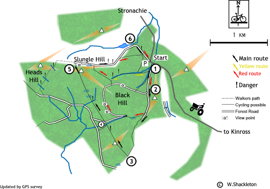
Watch out for the areas marked "!" on the map, they denote a hidden burns / streams (hitting these at any speed will have severe consequences) or steep rocky outcrops (step rocky drop-offs). If you are unsure about these dismount and walk.
The route
This route can be done either way, each has their merits. My preferred route is in the clockwise direction; it has a steep start up a forest road, along the westernmost red path and from near Slungle Hill, a great semi-technical (also known as dangerous) ending. The anti-clockwise direction has an easier start, then a bit where you will have to carry the bike up an outcrop and a fast finish. Suit yourself!
Clockwise route.
1: Lift the bike over the style; go left following the road uphill continue uphill to the fork, 2: take the right hand road. Follow the road as it meets the red marker post (on the left), turn right and follow this path to the edge of the trees.Turn left and descend back to the starting point using the red singletrack path through the trees or the faster road.
Health warning
A wider and harder loop, at 2. take the left hand fork and follow the forest road down until it meets a stone dyke (wall) then follow the grassy path uphill to the top of the fire break at 3. Descend taking note of the danger area at the bottom. A short distance later, cross the road onto another path and a hard climb to the top of Slungle Hill. 5: The path levels out, follow the path around to the right. There is a rough bit of boggy ground ahead, it is possible to cycle over it but look out for hidden ruts.
The going gets a lot better and exciting on the far side as the descent starts. It is at this point that you must decide how immortal you are. Look out for the steep drop off ahead, either dismount and walk this part or pick your line and go for it.... remember the advice about the route card?
The road resumes at the bottom of the drop-off and the going gets better, it is plain sailing all the way back, either return by the red path or 6: pass the small dam and follow the road around to the right. This will bring you back to the car park at the starting point, with I hope a big smile on your face.