
![]()
![]()
![]()
![]()
![]()
![]()
![]()
![]()
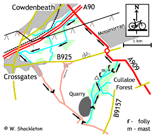
This 14 km or 9 miles route is for the mountain bikers and especially for those who do not mind getting muddy!
Cullaoe Forest is not too well frequented when it comes to mountain biking, however the follies makes for an interesting diversion in an otherwise nondescript forest. The rest of the run goes around Mossmorran using roads, well surfaced paths and farm roads into the villages of Crossgates and Fordel before returning to Cullaloe Forest.
I started this route at the small lay by just after the A92 outside Cowdenbeath, in fact you can start this route anywhere convenient. I chose to do this route in the anti-clockwise direction to get the most of the descent through Cullaloe and Culltehill farm, although the clockwise direction also has its merits.
Cowdenbeath, go to the right around the gate and continue along the road heading for the dual carriageway, as you reach the end of the track keep to the right beside the fence and follow the path.
At the bottom of the small dip is a bridge with difficult steps on either side of the bridge and a defunct access gate on the far side. It is best to get off the bike to negotiate the step and gate, as it is difficult to ride over them. Continue along the path going parallel with the dual carriageway.
The path then turns towards the trees; go through another defunct access gate, the path after the gate can be earthy in a few places. After passing under the power lines the path continues alongside a field before heading back to the trees. An access gate comes as a surprise just after rounding a sharp left hand corner, lift your bike over the gate and continue for a short distance to another gate.
After lifting your bike over this gate continue to the left along the farm road. Over on the right hand side, amongst the trees is a brick building and chimney this was the pit head baths of the old Alice pit. A path cuts across the farm road just before you get to the mature trees. Miners going between the pits at Fordell and Cowdenbeath used this right of way. Continue straight on along the well-surfaced farm road, at the end of the farm buildings turn left and then immediate right and follow this road down to Crossgates.
The farm road ends at a T-junction, turn left and continue along the mono-blocked road for a short distance before heading straight on to a grassy lane. After going down a short, earthy descent you cross a small footbridge to climb all the way past the houses to come to a road.
Turn left then immediate right signposted for Coaledge and Ansonhill. Follow this road down through the village. Just you leave the 30 mph limit a small road appears to cross this road, this was in fact a narrow gage wagon railway, which was used to transport coal from the pits at Mossmorran and the Fordell Pit (to your right at the concrete mixing plant) to the waiting ships at St. Davids harbour.
As you approach a small wood you enter a series of bends and a short sharp climb, exercise caution as traffic will not get much notice of you presence! Shortly afterwards is a junction, continue straight on. You will get good views to the right of the Forth bridges and the Lothians beyond from the top of the hill.
Shortly afterwards you will pass Goat Quarry, have a look for signs of activity, at the time of writing the quarry has been placed on a care and maintenance basis. If the quarry has reopened you will need to take heed of the next part.
Pass the quarry and enter a Z-bend and a 17% descent, immediately after the last bend, turn left and go up to the gate. The times of blasting are posted in this gate. Go to the left and around the gate and start the climb up the track. Towards the top of the climb you will start getting views of Edinburgh and the Lothians to the right and the quarry to the left.
Continue on this road until the end of the quarry, if you are inclined to sight-see there is a good vantage point at the top, just as you leave the edge of the quarry. Walking down to the tree line you can see Largo Law and Kirkcaldy to the left, Inchkeith Island, Inchcolm Island and the abbey and the Braefoot Bay marine terminal on the right.
The track starts to descend you will come to a series of fallen trees that block this road. The first one is easy as you can get the bike and yourself under the tree. After a short descent there is another set of fallen trees, go around to the right to rejoin the track. A short ride and another set of fallen trees back on the track you will climb up to more fallen trees. Back on the track once more and start to climb is the last set of fallen trees, this lot is considerably easier to get by.
The track finally comes up to a T-junction, turn right. Shortly after you will come to the first of the two follies in Cullaloe Forest. This one is an octagonal pavilion, if you go inside and look on the roof you can see names written on the stone, some dating back to 1899.
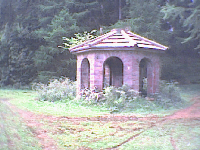 Octagonal folly
The path splits shortly after the folly. If you want to see the second folly, it is 550m along the track to the left. Otherwise continue to the right.
Going left, the road passes the radio mast and degenerates to a rough path, previous forestry operations destroyed the road. The path becomes very muddy at one point.
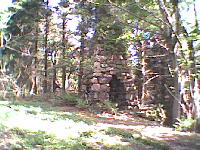 Tower folly
The second folly consists of a stone tower with through archways at the bottom. It is possible to continue to rejoin the track, by passing the folly and taking the left hand track and the technical descent to the forest road below. It is better to back track to the radio mast and road junction and turn left for an exhilarating 600 m, descent, followed by a short rise to the Cowdenbeath - Burntisland road. Go carefully around the barrier to the road.
If you wish to see another curiosity, turn right and go down the road for a short distance until you see a stone parapet. It is possible to descend the embankment to see the land-bridge, which must have been part of an impressive driveway to Cullaloe House. Back up the embankment and retrace your tracks to the forest gate to head into the cutting.
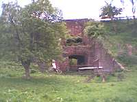 Land bridge
If you do not wish to see the land bridge, turn left at the forest gate, go through the cutting to the roundabout and go straight on passing the Fife Ethylene Plant on the right. After the second road, there is a set of bollards and a path. This path led to Gray Park, which because of the proximity to the Fife Ethylene Plant was demolished and the entire community re-housed in a new development to the north of Cowdenbeath, off the Perth Road.
Continue past Gray Park back to the starting point on the left.